Travelling down the old trackbed to Asmara
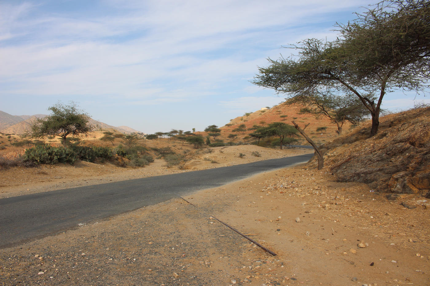
The chances of seeing the restoration of the railway line between Keren and Asmara seem pretty slim, but the trackbed is still driveable using four wheel drive vehicles. After our experience of the road from Asmara to Keren, which winds its way over the hilltops, I was intrigued to see how different the route forged by the railway engineers would be. The railway takes a much lower route, never straying too far from the river Anseba, so I hoped that at the very least the scary bends and precipices of the road wouldn’t be repeated!
A rare piece of track in situ at Halib-Mentel
As we set off in a convoy of four vehicles we all wondered how good the condition of the old trackbed would be, knowing all too well the problems with the section between Asmara and Massawa. Initially, the indications were not terribly good. A short while after leaving Keren (8.15) we left the road and joined the track (8.30) at a point where the track cuts across the main road near Halib-Mentel. We didn’t make it far before we were forced to return to the main road (8.45). Our drivers said the trackbed was in no condition for the cars.
We continued our drive down the main road, passing what our driver described as a former orange plantation established by the Italians in the early twentieth century. There was scant evidence of this to the untrained eye, bar for a villa and church overlooking the site that our driver pointed out to us. It was a familiar story – many of the terraces on the hillsides that we had seen during our week on the railway had once been planted with orange trees and the like.
In his book ‘Keren: A handbook’ (Francescana Printing Press, 2007) the late historian Mebrahtu Abraham explains that in the first phase of Italian colonisation the plan had been to re-settle unemployed Italians in large numbers and this would in turn help their agricultural projects. The rich arable land of the highlands in which Keren sits were a prime target for re-organisation into modern farms. In 1893 one of these settlers had established a modern farm at Ela Bared growing tobacco, green peppers and oranges. I assume this was the same farm that our driver had been trying to point out to us.

The ruins of the station at Ela Bared – including bullet holes from the war of independence
At Ela Bared we turned off the main road, taking a local road under a railway bridge (part of the old alignment of the railway), over the dry bed of a tributary, across the river Anseba, along a dusty track and finally reached the ruins of the station building at Ela Bared (9.30). The station platform and building have survived, albeit as a shell, with a square water tank wagon dating to 1915 (according to a plate on its side). There was also a circular structure above the station, presumably a water tank, with holes where a ladder must once have been attached.
The station building was marked with bullet holes from the thirty year war of independence (1961-1991). The railway and the passengers who relied upon it often ended up in the front line, as can be seen by a photograph from December 1970 showing a rebel soldier, with a Soviet made submachine gun, guarding passengers who appear to have been forced to disembark at Asciadira and another showing the deliberate derailment of a train at Asciadira.
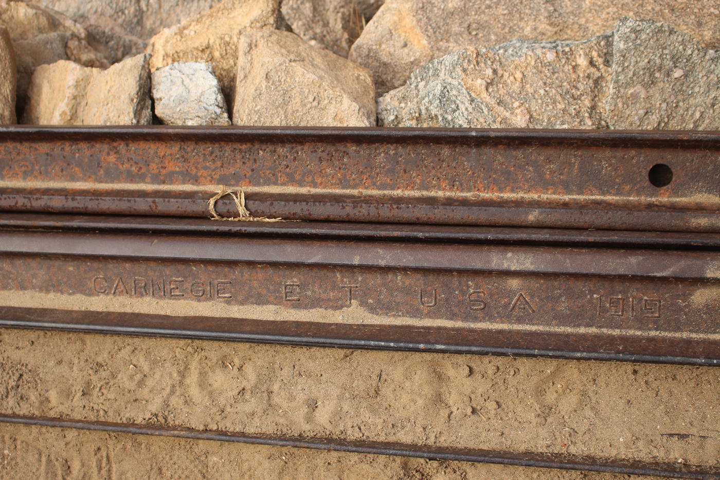
It was good to finally reach the railway and be in a position to start our journey in earnest, starting with the ‘new’ alignment of the railway. The first surprise as we started to drive along the line was just how much track was still around, usually stacked up to the side of the trackbed. At a stop by a bridge (10.00) we noted that most of this track was of US origin and dated 1919.
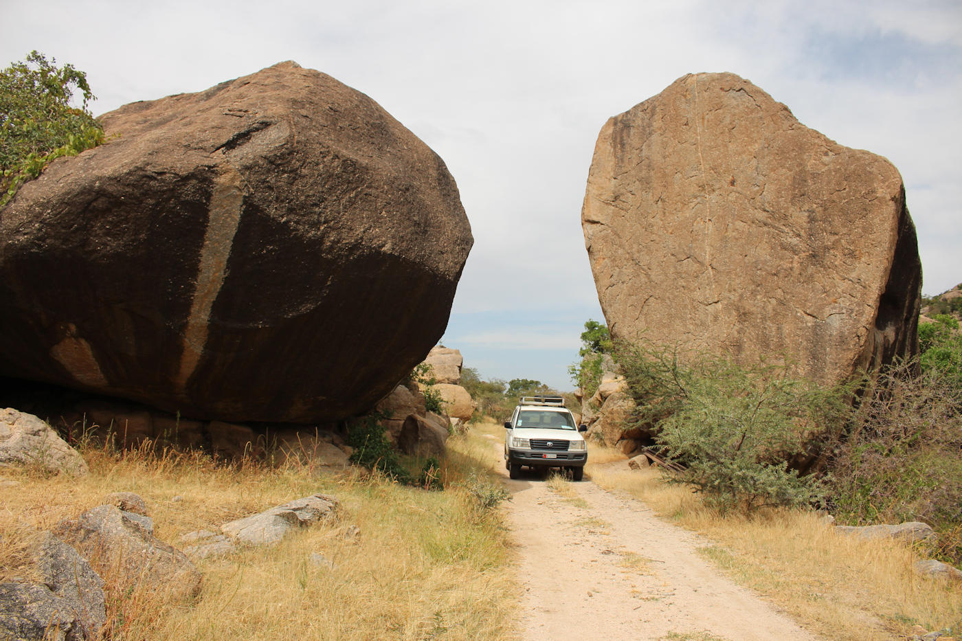
The spot featured in one of the most striking photographs from the 1940s
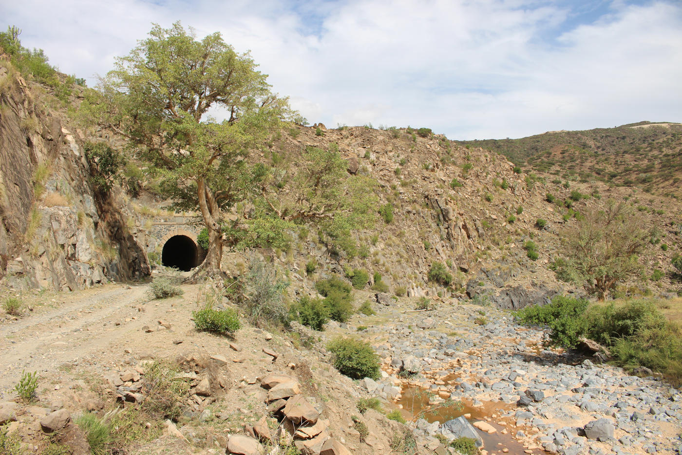
The next sights on our drive were the ruined station at Furkutu (10.45) and the two giant boulders just beyond (10.50) where one of the most well known photographs of the railway was taken in the 1940s (a Littorina between the boulders). It wasn’t long before we approached the entrance to tunnel 33, which surprised our driver who seemed to suggest that he hadn’t expected to drive ‘underground’.
I thought we had discovered Big Bird’s nest (of Sesame Street fame) but sadly the more mundane explanation was that haystacks were being constructed in the trees, presumably to help the hay dry quicker after the recent rain. After passing through the tunnel (11.00) and through tunnel 32 (11.15) we reached the next station at Amba Derho (11.45) to find that it too was being used for hay storage.

Big Bird’s Nest
Our four car convoy provided an entertaining runpast at a stone arched bridge (12.15). Besides the bridge we noted the presence of lumps of coal from the 1970s, which presumably fell off the loco at this spot before the line met its end.
At the next stop, at Abrascicò station (12.35) we took a longer stop, soaking up the atmosphere of the community that had sprung up around the station. The station building still has its name sign, which most have lost, and looked considerably better cared for as a family home. One of our group soon found himself surrounded by kids and led an impromptu and slightly bonkers english and drawing lesson which thoroughly won over the locals.

Abrascicò station
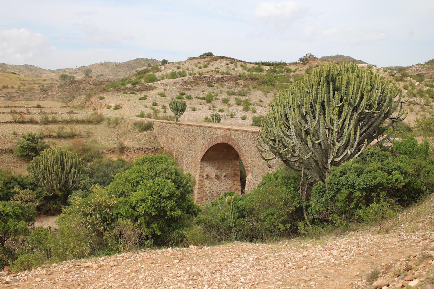
Our journey onward continued, reaching tunnel 31 in the early afternoon (13.30) where we noted a changeover from earth to something more like ballast on the trackbed. A little later we reached the next station on the line, Andennà (13.45), followed by the scenic setting of Dem Sebài (14.15) just after a single arched bridge in a narrow valley. Next up was tunnel 30 (14.30) and a sequence of three bridges. Not only was the scenery spectacular, the wildlife was pretty impressive too – ranging from squirrel like creatures to a family of jackals.
The final stop on our drive down the line was at a water column standing in splendid isolation on a relatively open stretch of track near Zazzega. There were a few blocks on a spot overlooking the column, but I couldn’t see any sign of any surviving station buildings. Of course, it is possible that we may have left the trackbed before reaching the station site. We turned off the line (15.25) as it crossed what looks like a relatively fresh unsealed red road, driving up to the main road into Asmara. It didn’t take long from this point to reach our accommodation at the Savanna Hotel (16:00).

Water column at Zazzega
It has been a wonderful day and gave us all a fascinating glimpse of the quite different scenery on this stretch of the line. It doesn’t look as though there would be any major obstacles to relaying a line on this route if the desire to do this is there barring for some re-grading of the trackbed and repair work to a few of the structures along the route.
Gallery


Railway remnants in Keren
Our afternoon sightseeing in Keren gave us a chance to see some of the remains of the railway in the city. The railway line to Keren opened in 1922 and was a significant factor in the development of the city, helping to transport the agricultural produce of the surrounding area to the capital. Two round trips a week brought passengers to and from Asmara.

The old station at Chèren-Tantarùa
The first stop on our tour was the station building at Chèren-Tantarùa at 222km from Massawa, just a short distance from the Sarina Hotel. The suburbs of Keren have swallowed this place up, so it no longer sits in isolation to serve a village. The station building has been adapted for housing and demonstrates the contradictions of life in Eritrea today – there are four satellite dishes on the roof but no-one has been sufficiently bothered to repair the roof, which is now falling in.
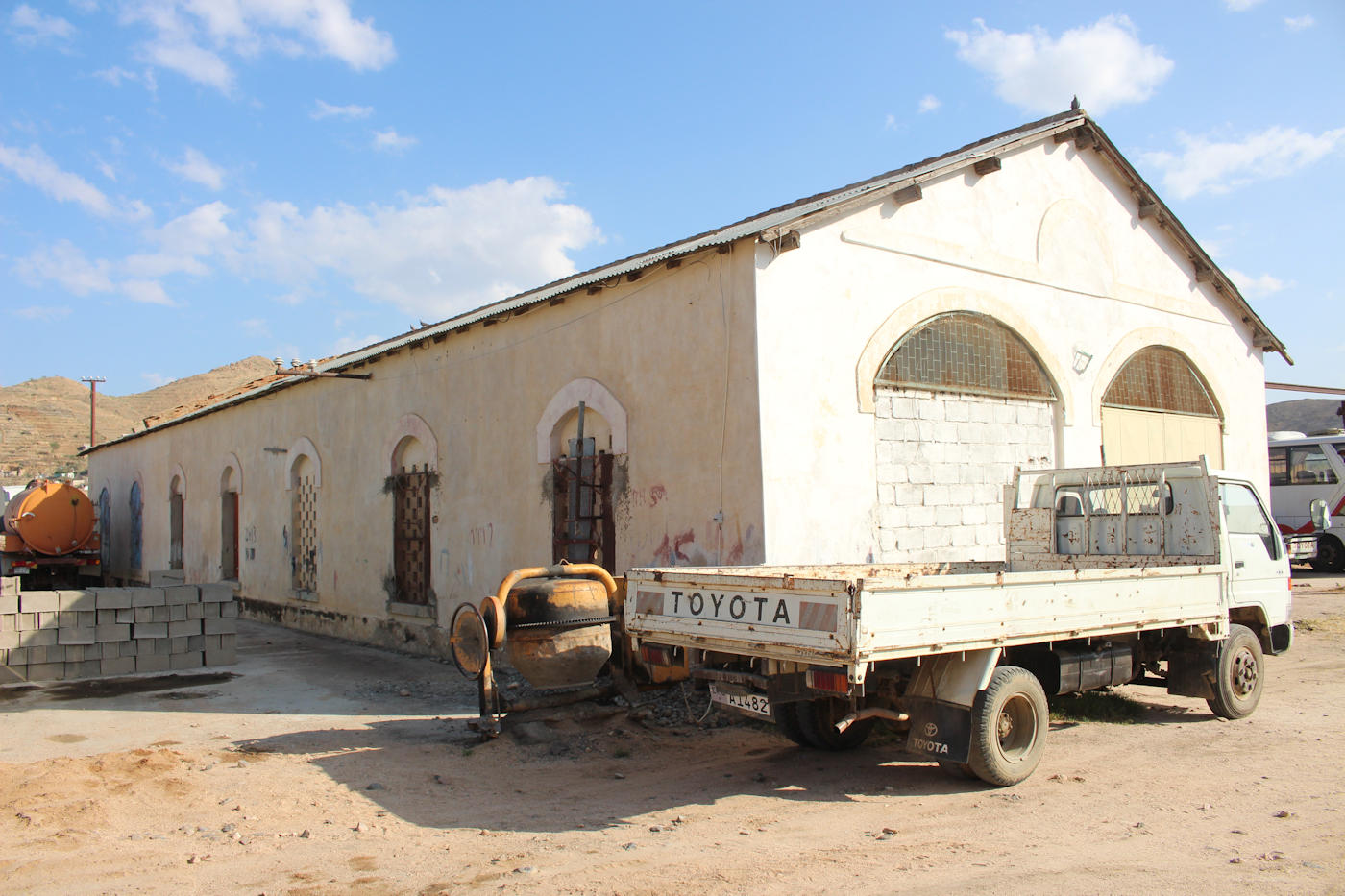
The next railway relic on our list was the depot at Keren, located 2km further on, now in use as a bus workshop and repair facility. The turntable and water tank from the railway are still visible here. A short walk away from the depot is the former station building for Keren (Chèren), now at the heart of the bus station. Inside the original decoration is still visible in the cafe with murals depicting local scenes on the walls and ceiling.

The old station at Keren (Chèren)
Finally, we visited one of the last remaining semaphore signals on the line between Keren and Agordat. It now stands in splendid isolation at a crossroads in the middle of a cluster of houses.
The railway may be long gone but it is clearly far from forgotten, as we encountered murals depicting the railway in two locations – one near the Giro Fiori roundabout and the other opposite the Ditta de Ponti building. Maybe one day the sound of steam engines will reverberate here once again, hard as that is to imagine right now.
Gallery


Sightseeing in Keren
Although the camel market was always going to the highlight of our day sightseeing in Keren there was still plenty to occupy our time all the way through to sunset. I will cover the railway remnants we visited in the next post, but here is a quick round up of the other sights we visited.

A view of Keren towards the Grand Mosque (built 1896, renovated 1956)
My out of print guidebook only devotes a few paragraphs to the city but a small 57 page book (Keren: A handbook by Mebrahtu Abraham) about the origin and development of Keren is available from the bookshop at the Giro Fiori roundabout. It’s an important work, based on interviews, that collects strands of local history that could all too easily have been lost.
Although the Italian period of rule tends to get the most attention, it is worth remembering that the Turks and the Egyptians had sought to colonize the area first. Indeed, wherever you wander in Keren you are overlooked by the hilltop Tigu Fort, built by the Egyptians during their short lived occupation of Keren (circa 1865 to 1884).
Our time in the city gave us ample opportunity to see some of the key sights, listed below, but this should not be regarded as a complete list of sights to see in Keren as there are other places that we did not get to, such as the Grand Mosque. Nor did we seek the permits needed to go and visit the battlefield sites outside the city.
1. The General Market
The general market, located on a dried up river bed in the centre of town, is a colourful affair and fascinating to watch from the bridge or mingling with the crowds. I was most fascinated to see camels loaded up with straw for roofing at the far end of the market. You would have thought I would have seen enough camels for one day, but apparently not.

The colourful sights of the general market
If you find yourself needing a drink to cool down after a visit to the market I can happily recommend the Red Sea Bar, located at a spot overlooking the nearby Giro Fiori roundabout. It was a pleasure to watch the world go by from their shaded outdoor tables.
2. The Shrine of Mariam Daa’rit
On a slow October day the shrine in the hollow trunk of a giant baobab tree seemed a quiet spot, but on one special day in May each year pilgrims come from far and wide to pray at this site and to see the bronze statue of the Madonna that was installed in 1878.

The shrine that contains the Madonna of the Baobab
It is said that a group of Italian soldiers sheltering inside during a mortar bombardment in 1941 emerged unscathed, despite a bomb breaching the tree (a scar which survives to the present day).
3. The Italian War Cemetery
The Italian war cemetery, laid out in 1950, is situated in a peaceful compound just off a dusty square. The site holds over 1200 burials, split in half between Eritreans and Italians with the flags of each country flying over the opposite section in reflection of their status as brothers in arms.

The Italian War Cemetery
It appeared to us as though they were treated as equals in death, though in his handbook the late historian Mebrahtu Abraham notes that the majority of the Eritrean graves have no names or ranks, whereas the opposite is true of the Italian graves.
4. Commonwealth War Graves Cemetery
The largest battle in Eritrea during the Second World War took place just outside the city of Keren in early 1941, following the withdrawal of Italian forces from Agordat. The Italian forces positioned 23,000 riflemen and a mixture of mortars and machine guns in the heights surrounding the deep gorge that carried the road in to Keren and on to the Eritrean plateau.
After months of hard fighting British forces led a surprise attack from the shelter of railway tunnel number 3, under Cameron Ridge, once it was cleared of mines. This action allowed the British to capture two crucial hills, Railway Bumps and Railway Ridge, which would ultimately lead to the fall of Keren. In turn, this was followed by the surrender of Asmara and Massawa.

Keren War Cemetery
The appearance of Keren War Cemetery would be pretty familiar to anyone who has visited the battlefields of France and Flanders, albeit with earth rather than grass at your feet. The grounds contain 440 Commonwealth burials from the Second World War, of which 35 are ‘Known unto God‘. A separate cremation memorial stands within the cemetery to remember 285 Sikh and Hindu soldiers from India and Pakistan killed on the battlefield at Keren.
5. The Italian Quarter
The central district of Maekelay Ketema, known as the Italian Quarter, was reserved for the Italians during their time in power here. It holds some of the most striking buildings in the city, including the Ditta de Ponti building (1916), the former Governor’s House, the villa of the Italian Police Commissioner (1910s), the red brick Catholic Cathedral of St Antonio (1932), the Cinema Impero and the Casa del Fascio (1930s).
Some of these buildings have been restored, such as the former Governor’s House, which is now a municipal office. Others looked to be in varying states of decline and decay.

The Ditta de Ponti building
Not all the sights in this area were historic – a modern cathedral of St Antonio has been constructed alongside the older church (2006) with striking blue domes. Amusingly, a closer examination of the Cinema Impero showed a notice for a screening of the upcoming match for Crystal Palace (my local team) which was the last thing I expected to see here!
6. Rooftop bar at Hotel Keren
Our day came to an end at the Keren Hotel (1971) which offers a rooftop bar with a marvelous view over the city and a ready supply of Asmara beer. It proved to be a popular spot – we shared the sunset with two other groups: an Italian tour party and a German medical mission based in the city.

The Keren Hotel and observation tower
The hotel is topped by a rather precarious observation tower, located atop a seemingly unsupported concrete column with a wobbly metal staircase strapped around it. It can only support a couple of visitors at a time. When an entire tour party turned up and tried to climb up everyone screamed in unison. The mime of a collapsing tower didn’t need much explanation! In truth, I am not sure the small improvement in view merits the risk involved – the view is perfectly fine from the rooftop terrace.
Gallery


Camels for sale
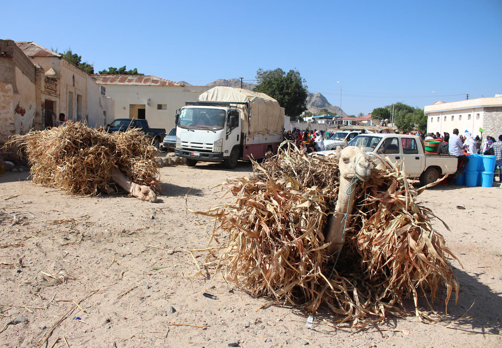
The weekly camel market, held on Mondays, is one of the must see tourist sights in Keren according to my old and out-of-print guidebook. The market is located in a walled compound a little way out of town on the road to Nafka, accessed from the sandy bed of a dried-up river. It actually offers much more than camels, including goats and cattle, but inevitably it was the more exotic creatures that caught my attention.

The camel and cattle markets
Although the market nominally starts around 8am, a few of us opted to skip breakfast and head down to the market am hour and a half earlier to see the camel market being set up. It wasn’t that hard a decision to make, having seen how painfully slow it had been for the hotel to rustle up dinner the previous night. In truth, after a week of omelette for breakfast and omelette rolls for lunch (with the occasional chilli to catch you off guard) I was happy never to see another omelette again!
I wondered if I had made the right call when the bus dropped off, sensing that despite the market’s appeal as a tourist attraction we were the only westerners wandering around. However, after the initial curiosity faded everyone got back to herding their charges towards the market, setting up their stalls and greeting their fellow traders. Nevertheless, with animals wandering in every direction, you still had to keep your wits about you.
The spectacle felt timeless. I think you could have stumbled into the same place a couple of centuries back and seen hardly any differences in the way that the market operated. A little bit of negotiation on the dry river bed, perhaps a cup of tea brewed in a structure assembled on the morning and then the main event. It was a privilege to be able to be able to wander so freely and watch events unfold.

Inside the camel market
Inside the compound potential buyers were testing the abilities of the camels for sale from sitting down to getting on their knees and so on. There must have been at least 50 camels in the compound when we arrived, though it is hard to be precise as the numbers were fairly fluid. Camels were still being led to market as we left, while others were already on their way home with their new owners.
Beyond the camel compound was a much larger market for cattle, including a ploughing area to put potential purchases to the test. I would guess there were around a couple of hundred animals in this space.
Upon entering the cattle market, I noticed that the man in front of me had dropped an envelope containing all the money he had obviously brought to buy some animals. I tried calling out, but quickly realised that no amount of calling in English was going to succeed. I picked up the stash and went to run after him, but then stumbled on the uneven ground and almost started a cattle stampede! The commotion of the one bull I had managed to startle was enough to get the trader to turn round and I was able to return his cash. All’s well that ends well…

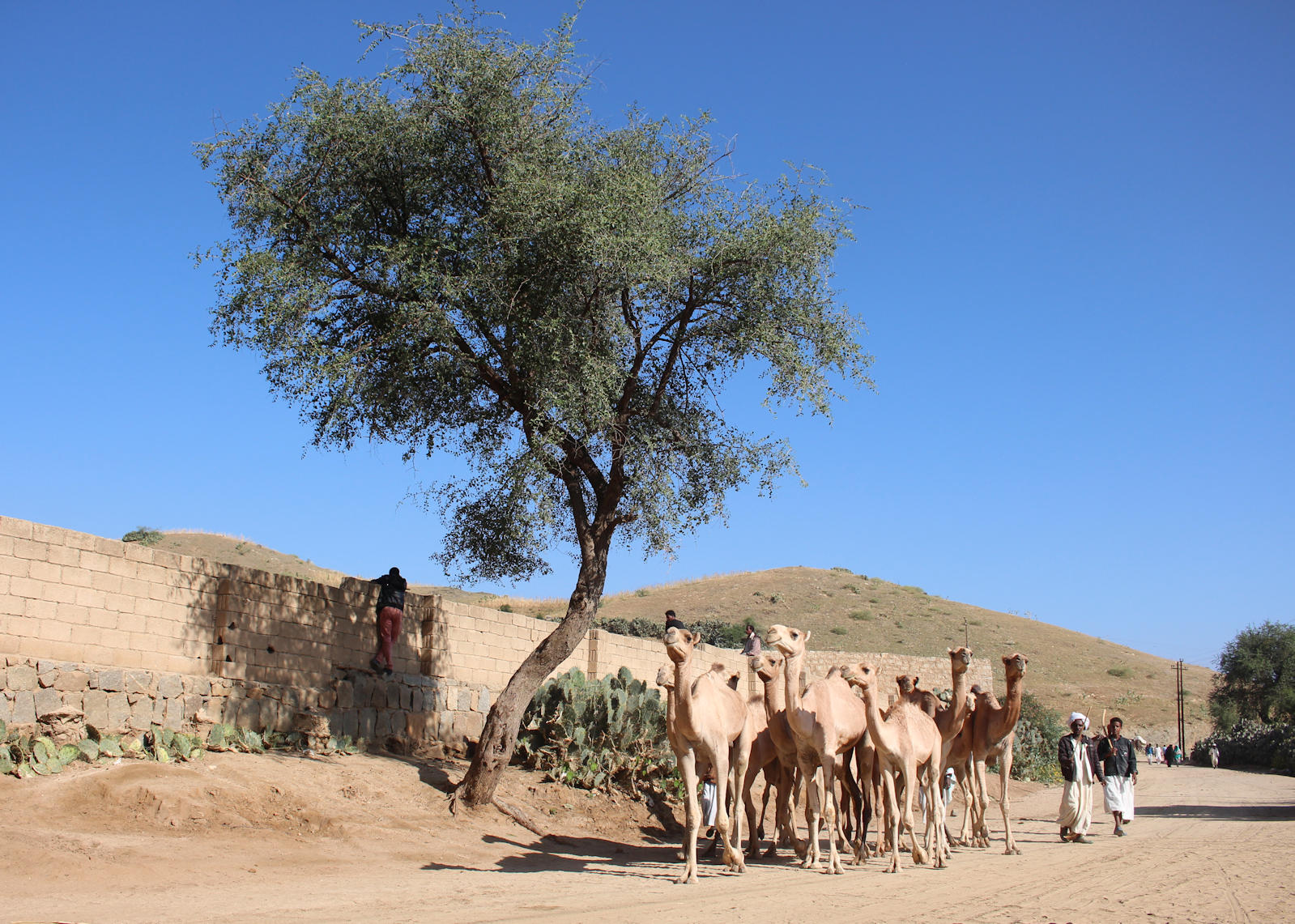
One last train of camels on the way to market
Our time at the market came to an end at 9 o’clock. It was long enough a stay for me to have racked up a couple of hundred photographs, but there was still room for a last photo or two as a camel train passed by on the way to market. You can never have too many camel photographs it seems!
Gallery


The road to Keren
Our week long photo charter through the mountains might have been over, but we were far from done with Eritrea.
On the morning after the photo-charter I joined a smaller group to see the sights of the capital, Asmara, and the second largest city in Eritrea, Keren. To some extent we had already seen quite a few of the sights of the capital as we traveled to and from the railway, but Keren would be entirely new to us. I was intrigued to discover how far the Italian influence extended beyond Asmara.
The railway line between Asmara and Keren has not been restored so our journey would take us on the winding roads through the rugged hills and then down into the river valley to the city. It is approximately 80km north-west of Asmara. Our initial estimate was two hours, but it turned out to be closer to three and a half hours allowing for stops along the way.

The debris of war sits beside the road to Keren
Along the way the drive, which began at 2.30pm, gave us an opportunity to see the changing landscapes of the Anseba Region as well as some of the debris left over from the 30 year war for independence. At one spot we stopped to see two armoured vehicles by the roadside, then a tank in a gully and lastly a village with two rusting tanks as a centrepiece. I opted to skip the last ‘request stop’ as the bus was besieged by kids with baskets of fruit trying to make a sale.
Besides the relics of war there was plenty of stunning scenery to admire, though one memorial at a hairpin bend illustrated the perils of the road. At another we saw a mother nursing a goat that she had just given birth to and then for good measure some children waved chickens at us as we left the hills and drove along the valley floor! Striking also to see the change in building styles, with many traditional huts with thatched roofs now included in the mix, as well as industrial activity, such as the brick making on display all along the riverside.
The sun was just dropping below the hills as we walked into our hotel for the next two nights, the Hotel Sarina, located just on the edge of town. Indeed, it could be described as being barely in the sprawl of today’s city – the official checkpoint for entry was located just outside the hotel gates.
The hotel looks somewhat plusher than the one we left behind in Asmara, with a soft bed that I could already feel tempting me. I even have a balcony that overlooks the huts on the fringe of the city and a selection of abandoned/burnt out cars by the petrol station. It’s not perfect (curtains falling off the rails, power sockets coming off the walls and only half the lights work) but it will do. The only real difficulty was trying to get food before falling asleep – it took one and a half hours for the hotel restaurant to serve up the pizza I ordered for dinner!
Gallery


leave a comment