Auckland to London
Our long journey home started at Auckland Airport in the early hours of Tuesday morning. We had stayed overnight at the Novotel Auckland Airport which is just a few metres away from the international terminal. For location it couldn’t be beaten, though the restaurant proved to be a bit of a disaster zone.

Qantas 737-800 (VH-XZI) awaits us at Auckland’s International Terminal
Although we were travelling in economy we were able to benefit from the status that my better half had unintentionally acquired last year (something that was so accidental we know it will never happen again). This allowed us to bypass the queue of 100+ passengers to drop our bags using the priority queue, take a spot of breakfast in the Qantas lounge and use priority boarding to get on to our first plane, a Qantas 737-800 (VH-XZI), for QF142. It was something of an eye opener to see how much easier life can be for frequent fliers.
Our flight took off just after 8am and, if the flight map was to be believed, was on course to be almost an hour early! I suspected this would prove too good to be true and sure enough, it wasn’t too long before we were drawing squiggles in the sky. In the end we still landed 25 minutes early. Unlike our last hop across the Tasman sea this one was completely uneventful. We had a good view of the beaches at Piha and Whatipu as we headed westwards, then a stunning overhead view of the rock shelves in Sydney’s Royal National Park as we came into land.
The next leg on our journey took us from Sydney to Singapore on an A330-303 (VH-QPE) departing almost an hour late at 12.38pm. The Captain explain over the PA system that the late departure was due to the late arrival of the aircraft being pulled onto stand and a catering issue – waiting for some bread! In the end they made the decision to give up on the bread and go. They had taken on extra fuel so hoped to use this to make up the lost time.

A330-303 (VH-QPE) passes Cronulla Beach shortly after take off
We were treated to more terrific views over Sydney as we headed away, this time over Cronulla Beach and up the Georges River. Our crew made excellent time and we were on schedule to land on time, but at this point they were asked to hold due to some weather at the airport. After a bit of circling we landed at 6.28pm, so not too far behind our scheduled time of arrival. Two flights down, one to go.
Every time I have passed through Changi Airport I have been astonished by the sight of so many ships in the Straits of Singapore. This time proved no exception, with our flight passing over hundreds of vessels on our final approach, beautifully illuminated midway through the golden hour.

A330-303 (VH-QPE) passes over ships in the Straits of Singapore
The final leg of our homeward journey was five hours away, so my better half once again used the benefits of status to get us into the large Qantas Business Lounge at Changi Airport, which offered dishes freshly cooked by a chef while we watched (a choice of a stir fry black pepper beef or their signature chicken laksa with tofu and rice noodles). The food, and a glass of a rather nice Brown Brothers muscat, revived us for a bit, but we were soon falling asleep at our table trying every trick we could think of to prop our eyes open.
Finally, the gate opened for QF1, operated by a Qantas Airbus A380-800 (VH-OQB). We usually buy bottled drinks to take on board flights but this is pointless at Changi as the security checks take place at the gate. All I could do was drain my drink and refill the bottle at a water station beyond. Once on board there was a long trundle out to a far runway, eventually taking off at twenty past midnight, some 50 minutes late. This time the delay was due to plumbing issues. We were told that water had mistakenly been put into the wrong tanks so the load controllers had to resolve that before we could go.
We had been struggling to stay awake and finally gave in, helped by the adjustable Qantas headrests in our economy seats. I managed five hours of sleep, which may well be the most I have ever achieved on a long haul flight. That still left nearly 9 hours of flying, but the IFE really helped. I enjoyed a viewing of ‘The Fabelmans’ among other films and TV programmes.

Qantas Airbus A380-800 (VH-OQB) at Heathrow
At 7.05am we made it on to the ground at Heathrow, just half an hour late. I certainly couldn’t complain about that as QF1 had picked up much bigger delays in the week leading up to our flight (including one flight that was almost six hours late).
The time from check in at Auckland to walking out of the baggage hall at Heathrow was 38 hours and 45 minutes (or exactly 41 hours from the door of our airport hotel room to our front door at home). These long flights always terrify me, yet somehow you get through them. I’m not sure that we’ve found the perfect way to get to and from NZ. Maybe it doesn’t exist and every option is imperfect in some way!
Gallery


Auckland days
Our time in New Zealand included five days in Auckland, mostly time spent with family, but we did manage to go on a rather wonderful guided tour of The Civic in Auckland.
The Civic originally opened as a movie palace in 1929 with an ambitious capacity of around 3,000 that they could never realistically hope to fill regularly with the size of the population in Auckland at the time (circa 100,000). Nevertheless, it captured the imaginations of the local population from the outset – and no wonder, it still blew my mind today! It all fits with the story of a theatre that could never be described as ordinary or predictable.

The lobby of ‘The Civic’ in Auckland
I am familiar with plenty of richly decorated theatres at home in London, but I still can’t think of many that would stand up to the exotic interior decoration of The Civic. It’s quite a mish-mash of cultures, rather than sticking to one theme. You have an astonishing array of Buddhas, 400 plaster elephants, Moorish minarets and Abyssinian panther statues. The ceiling of the auditorium presents the night sky of Auckland as it appears every year at 10pm on 20th April with drifting clouds and even the occasional shooting star.
The Civic was run-down for many years and was under threat of demolition for a while but ultimately underwent a full restoration in 1999. It’s a stunning survivor, though there are fresh clouds on the horizon with the mayor’s funding cuts. I thoroughly recommend the guided tours, for the fascinating full story of this theatre, its genesis and many scandals – especially in the capable hands of a tour guide like Tomoki.

The Nautilus
On another day I enjoyed a fantastic morning exploring the Maritime museum followed by a one hour long harbour sailing on board the Nautilus, a 110 year old harbour launch with a capacity of six, plus crew. The tour took us across the water to the navy base, under the Auckland Harbour Bridge, into the Wynyard Quarter and then back to the museum.
The Nautilus proved to be a fascinating vessel with a rich history. The launch was built by Collings & Bell of Auckland in 1913, using kauri (with teak fittings and mahogany furnishings), and not really intended for sea going, with a curved bottom that means she can get easily affected by the wake from other ships. Although she started life as a pleasure craft she was offered to the New Zealand government in 1915 to help with the war effort.
In World War 1 she was carried on the hospital ship Marama as a tender, serving in Greece and Turkey, where the Marama was used to transport wounded soldiers from Gallipoli and the Western Front to England and New Zealand. In 1919 she returned to recreational use in New Zealand, initially with excursion trips. The Nautilus returned to that role for the Maritime Museum in 2016 after a full restoration.

St Heliers Bay at sunset
Any trip to Auckland invariably includes some good ice cream and minigolf. Our favourite ice cream parlour on this trip was Island Gelato, with five stores in Auckland and on Waiheke, including one in the Auckland CBD-Ferry Building. Amazing flavours on offer included coldpress coffee affogato, pineapple mojito and golden peach iced tea. As for the minigolf, we revisited old favourites, Around the world at Sylvia Park and The enchanted forest at Onehunga (a really beautifully maintained and tricksy course), plus a new place called Holey Moley on the viaduct.
The most important thing about Auckland is spending time with family but it’s always nice to do a bit of sightseeing around that. I am slowly ticking off a list of sights around Auckland, a few on each trip and plenty more to go.
Gallery


Silverstream Sunday
It can be a little tricky planning visits to the volunteer-run heritage railways in New Zealand during a short-ish trip to NZ as many have limited opening hours, nevertheless it is worth persevering as these are usually rather wonderful set-ups. On this occasion, I was lucky that my last minute trip happened to coincide with the operating days for the Silverstream Railway (usually the first and third Sundays of the month, plus selected public holidays).
You can reach Silverstream Railway easily enough by train from Wellington, even when is a little bit of bustitution involved (rail replacement buses were running between Wellington and Petone on the day of my visit). The heritage railway was an easy 20 minute walk from Silverstream railway station via County Lane and the Hutt River Trail. On the way I stopped at the railway bridge over the Hutt river, taking shots of the morning passenger service on the Wairarapa Line to Masterton topped and tailed by KiwiRail diesel-electric locos (7064 and 7145) and the regular Matangi multiple units used on the the Hutt Valley Line.

RM30 railcar at the Silverstream Railway
The heritage railway uses the old alignment of the railway line to Upper Hutt, completed in 1875, which used to cross the Hutt River via a wooden trestle bridge. As this bridge was unsuitable for electrification a new bridge was built further upriver. The redundant section of line was closed in November 1954 and remained out of use until the 1970s, when the Silver Stream Railway purchased the old line. The first heritage train to operate on the rebuilt line ran on 31st December 1978, but the full 1.5km extent of the present line was not reached until 1986.
On the day of my visit the volunteers were running diesel railcar RM30 (named Aotea after the Maori waka) which was built at the Hutt Railway Workshops in Lower Hutt in 1938 (one of six railcars in this class). It retired in 1972 and was purchased by the Silverstream Railway later that year.
I enjoyed a ride up the line and back again which was short and sweet, with a glimpse of their other locos along the way (such as diesel electric loco DE580 built by English Electric at Preston in 1951). There is no station at the other end and it is not usually possible to visit the workshops/storage facilities, but there are a couple of small exhibition spaces to visit (one a preserved NZR workman’s hut and the other with a modest display about the railway). I stayed for around an hour.
Thank you to all the volunteers that made my visit to the Silverstream Railway such a delight. Also a pleasure to unexpectedly meet up with some fellow photographers from the FarRail tour to Sri Lanka in 2020. It really is a small world sometimes…
Silver Stream Railway are currently facing a threat from a proposal to develop a transport and infrastructure corridor through the nature reserve that runs alongside the railway. More information on the threat is detailed on the Silverstream Spur: Always a reserve, never a road. campaign page.
Gallery from the Upper Hutt/Wairarapa Lines


Wellington weekend
A last minute revision to our plans saw me head to Wellington for the weekend, flying down on an Air New Zealand domestic flight at midday on Friday. I was struck by just how easy it was to get in to the city centre by public transport, armed with a newly acquired Snapper card, in complete contrast to Auckland airport.
After dropping my bags I took the number 2 bus out to Karori Cemetery, where the office staff were kind enough to print out a map showing me where to find a family grave (my great-great uncle married a lass who grew up in Whanganui). While I was at Karori I spent some time looking at some of the other notable graves in the cemetery, such as the survivors of the S.S. Penguin Shipwreck and graves of service personnel from WW1 and WW2.

The Shelter at Karori Cemetery (1891)
I also visited the Tangiwai National Memorial, which remembers all those who lost their lives when the Wellington-Auckland overnight express, hauled by a KA class steam locomotive, plunged into the flooded Whangaehu river on Christmas Eve 1953 with the loss of 151 of the 285 passengers on board. The disaster was caused by a lahar that struck and weakened the supports of the rail bridge. Prince Philip, Duke of Edinburgh, who was on a tour of the country with Queen Elizabeth II, attended the State Funeral at Karori on 31 December 1953. The memorial was unveiled on 26th March 1957.
One of the more recent additions to the cemetery has been a monument to Mrs Chippy, the tabby cat looked after by carpenter (chippy) Harry McNish on Shackleton’s grandly titled but disastrous Imperial Trans-Antarctic Expedition, 1914–1917. The crew of the Endurance, including McNish, had to abandon ship when it became trapped in the ice. Sadly, Mrs Chippy couldn’t be taken with them and was shot.
Harry McNish was given a full naval funeral on his death on 24th September 1930, but in spite of this, languished in an unmarked grave until the NZ Antarctic Society added a headstone (1959). The Society later raised the funds to add a sculpture of Mrs Chippy (2004) intended to look as though he was lying on McNeish’s bunk. It should be noted that although named Mrs Chippy by the crew, it later turned out that Mrs Chippy was a male cat!

Monument to Mrs Chippy at Karori Cemetery
One of the key attractions luring me to Wellington was the exhibition Gallipoli: The Scale of Our War at Te Papa. The publicity material described it as a ground breaking exhibition and they were not wrong. The exhibition fuses together a masterly day by day walk through of the campaign with six extraordinary giant sculptures (made by Weta Workshop, famous for their work on the Lord of the Rings films) that are 2.4 times human size.
I spent exactly two hours in the Gallipoli exhibition – literally looking at every display and engaging with every interactive screen in a way that I never normally do. I came away with a much better understanding of the battle (and where one of my distant relations, Ernest Felix Kent, would have fitted in to this). It would be no exaggeration to say that this is one of the most well put together and compelling exhibitions I have ever seen.
The exhibition was originally scheduled to close in 2019 but has since been extended twice and will now not close before Anzac Day, 25th April 2025.
On top of this, I found plenty of interest at Te Papa that was new since my previous visits (1998 and 2013) and especially enjoyed the artworks on display. I have not come across the artworks of Tony de Lautour before, but found his “restorations” of 19th century paintings found in junk shops fascinating. The restorations add in fantastical and hostile beasts hinting at the darker history of empire.

Gallipoli: The Scale of Our War
On my second day in Wellington the forecast sounded challenging, suggesting a 90% chance of rain all day long. When this didn’t materialise I switched plans and sought out a super piece of street art by Taranaki artists BMD at 79 Cable Street (featuring around 190 sharks, created as part of a campaign against the practice of shark-finning) and another piece by Sheffield-based street artist Phlegm at the back of the Walrus Gallery in Jessie Street.
I also made a stop off at the City Art Museum for the exhibition Reuben Paterson: The Only Dream Left (25 February 2023 to 18 June 2023). Paterson’s works provoke many questions, but the lovable bear sculpture ‘David’ (2012) perhaps struck me the most, delibertaely placed to gaze upon another artwork as a stand in for a gallery goer struggling to process the work in front of them.

Street art by BMD
One of the unexpected pleasures of my visit was Wellington Museum, where I spent a good two hours wandering around (lots of interactive elements and just downright brilliant explanation). It was under renovation when I came in 1998 and we didn’t visit it in 2013. I had no idea what I was missing! It’s really engaging on every floor – with a poignant section on the Wahine disaster and a wonderfully eclectic collection in the attic that just kept surprising me (ranging from a rather grumpy depiction of a kiwi through marquetry to a sandblasting suit).
Finally, it goes without saying that any trip to Wellington offers a pleasurable mix of art deco architectural wonders. I made good use of the Art Deco Heritage Trail guide to help me understand what I was seeing across the city centre, including the South British Insurance Building at 326 Lambton Quay (1936) which is today home to Chartered Accountants Australia and New Zealand.
Although my visit to the city was relatively short, it packed plenty in and thoroughly delighted me from start to finish (not forgetting the wonderful contributions that Weta Workshop have made to make the airport more fun, such as a blinking Smaug in the check-in area and eagles soaring above the food court). I’ll have to remember not to leave it quite so long before I come back…
Gallery


A unique homegrown railway
Our visit to the Driving Creek Railway was the highlight of our visit to the Coromandel and something that I had been looking forward to for a fair few years. It proved to be every bit as extraordinary as I hoped.
The story of this unusual railway began when potter Barry Brickell (1935-2016) bought a hilly 22 hectare plot of land in the Coromandel and started a homegrown narrow-gauge railway to transport clay around his site, which eventually extended to 3km. Although it began as a solo effort Barry attracted many others as word spread. The line was opened to the public in 1990, some 17 years after it began, allowing the public to share in Barry’s unique vision.

Driving Creek Railway
The 15″ gauge line was mostly built by hand and includes eight bridges/viaducts (one of which is a double-decked), three tunnels, two spirals and five reversing points on the climb up to the peak by railcar. The steepest climb on the line has a gradient of 1 in 15. It’s damn impressive.
On a ride up the line (one hour return) you get to see some of the pottery sculptures that have been installed along the route, take in some spectacular views and generally marvel at this unusual creation. I particularly liked the tunnel which has immortalised the faces of those who worked with Barry, including our driver, in pottery form.
The journey starts by passing through the brickworks and the railway workshop where the earliest locomotives, such as Mouse (1978), can be seen. It’s not the easiest line to photograph, so it’s much easier to just sit back and enjoy the ride through the lush forest of regenerating kauri, rimu and ferns. With your ticket you get a super line diagram too that helps you follow your progress along the spirals, switchbacks and bottle lined walls.
Once you reach the top of the line you can stretch your legs and admire the views from the Eyefull tower (completed October 2003) at 178 metres above sea level, whose design was inspired by Bean Rock Lighthouse in the Waitematā Harbour in Auckland. The panorama of islands stretched out between Te Kouma and Whangaparāoa looked marvellous from the balcony at the top of the tower.
Barry died at the age of 80 in 2016, but his creation lives on as a much loved railway, pottery and conservation park, drawing tourists from far and wide. Long may it continue to delight visitors.
Gallery


A short trip to the Coromandel
Our plan to take a trip to the Coromandel unravelled somewhat in the wake of the terrible news that emerged from New Zealand in January and February, when extreme weather felled trees, caused severe flooding and triggered landslips that cut many of the roads across the region. After some reflection, we opted to continue with a shortened version of our trip, following the request to avoid some roads that were available only for essential travel.
I feel for the businesses in the area that have lost money from a succession of compromised summers and now have to cope with the devastation wrought by Cyclone Hale, the Auckland Anniversary weekend floods, Cyclone Gabrielle and the three week long state of emergency that followed.

One of many examples of the damage to the road network
The revised plan chopped out the popular sights of the eastern coastline, such as Cathedral Cove and Hot Water Beach, in favour of a shorter stay centred around Coromandel Town. Signs of repair work underway were a regular feature of the drive up State Highway 25 and in our drives beyond Coromandel Town. There was plenty of evidence of slips, though nothing remotely approaching the scale of the massive slip that severed State Highway 25A.
On the way up to Coromandel Town we stopped at Thames and made a snap decision to visit the Thames Goldmine Experience. It was a great move – the guided tour of the underground mine passage was a great start, but the ability to see an operational 19th century stamper battery in action was just amazing.
The demonstration of the machinery was incredibly loud (ear defenders supplied) with just 5 of the 18 stampers that would have been in operation. I can’t begin to fathom how folk worked there at the peak of its operation. Only one volunteer was running everything on the day we arrived, from collecting fees to running the tours, but it was one of the best industrial museum experiences I can recall.
After making our way out of town we made a stop at the Waiomu Beach Cafe for a spot of lunch. In a morning that was already defying all expectations I was once again wowed. This time it was the incredible selection of home baked goods on offer widening my eyes. It was quite possibly the best bakery I have ever been to in New Zealand. The food I tried was extraordinarily good (a spicy beef and blue cheese pie, followed by a peach and cream cheese swirl). To be quite honest, I could have spent a few days in the Coromandel just working my way through their incredible baked treats!! I was certainly left salivating at the prospect of a stop on the way back to Auckland…

Long Bay in the Coromandel
Our accommodation was a delightful two bedroom studio unit on the beachfront at Long Bay Motor Camp, just outside Coromandel Town. The setting was gorgeous with a terrific view out over the bay; a charming and well tended walk through a Kauri grove accessed directly from the camp grounds; and some wonderfully dark nights for stargazing undisturbed by streetlights. A visit from the camp cat sweetened an already perfect spot.
After dropping our bags we headed over to the remarkable Driving Creek Railway. I have visited a few industrial railway lines over the years, but I have never seen anything quite like this. In the evening we sat on the decking with our supper, watching grey heron, oyster catchers and gulls on the beach as the sun faded. Eventually we retreated indoors for a few rounds of cards. Happy times.
The next day we took a drive up the coast as far as we could reach. Here the damage from the summer storms was much more apparent with orange and yellow markers reducing the road to one lane where there have been slips or where the road has cracked and fallen away. In the afternoon we took a charming wander through town using a map of 30 historic buildings, many from the 1870s boom after the official declaration of the area as a goldfield. Copies of the trail map are available from the Coromandel Town Information Centre.
Our homeward journey to Auckland took us back down State Highway 25 to Waiomu Beach Cafe, through Thames and then onto a wonderfully scenic drive along the coastal roads via Miranda, Orere Point and Maraetai.
Gallery


Waiheke and Stony Batter
A day trip out to Waiheke, the second largest of the islands in the Hauraki Gulf, has been on my wishlist ever since the tunnel complex at Stony Batter re-opened to the public in 2020 after a five year closure.
It was something of an early start for us with a booking for the 8 o’clock crossing on the Sealink car ferry from Half Moon Bay to Kennedy Point, but we were blessed with a beautifully autumnal morning and the views were simply stunning – including Tahuna Torea and Sandspit beach; Musick Point with its art deco radio station building; and the ever green Browns island (Motukorea). It was a quiet and calm crossing, somewhere around 45 minutes.

Seacat, our ferry to Waiheke, is the largest in the Sealink fleet
Our day got going with a reviving coffee at Charlie Farley’s, a popular eatery in Onetangi, then we heading off on a drive into the less-populated half of the island, along Waiheke Road and Man O’ War Bay Road to a parking spot part way up Stony Batter Road. A short walk on from the car park brought us to the entrance to the Stony Batter Historic Reserve and the tunnel complex hidden beneath the fields in a deliberately remote location.
The tunnel complex at Stony Batter was built in complete secrecy between 1942 and 1948 with a camp on the surface housing up to 190 soldiers and construction workers. It was the largest of three gun batteries in the country, built to defend the anchorages in the Hauraki Gulf, which the US navy was using. It’s unusual in many ways, not least in re-using existing plans for NZ railway tunnels to save time! Some of the problems that have affected the site since then, such as flooding, are partly a reflection of the speed at which the site was constructed.
It’s all somewhat mind-blowing in scale, with 1.2km of tunnels (around four times the height of Auckland’s Sky Tower) and many fascinating spaces to explore on a guided tour. The team have done a terrific job of restoring the internal chambers, with our tour guide taking us to a large magazine chamber, one of the three gun turrets, the engine room and the plotting bunker. We exited through “prehistoric jungle” after a fascinating 50 minutes.

The well hidden exit from the tunnel complex
After re-emerging into the sunlight we made our way over the road on a path (indicated by wooden marker posts) through the rocky outcrops of the boulder field with some truly stunning views across the water. The visit to the tunnels was wonderful and this was just the icing on the cake!
On completing our tour we returned to Onetangi Beach and found a bench to eat our delicious homemade ham and egg pie. After that, we still had time enough left before our return crossing to take in a beer tasting at Wild on Waiheke, see the impressive setting for the Mudbrick Winery and check out Oneroa Beach.
Our day on Waiheke was quite wonderful. It was terrific to get to visit Stony Batter after hearing about it for many years. The plans to develop the space sound really exciting and I wish them well.
Gallery


Highlights from New Plymouth
Our time in New Plymouth has come to an end. I’ve already written about much of the sights we’ve seen in the region, but there were some pretty marvellous attractions in the city centre as well.
First up is the Govett-Brewster Art Gallery which is combined with the Len Lye Centre, the first museum in New Zealand devoted to a single artist. During our visit the exhibition Len Lye: Atomic Power was running, providing a fascinating glimpse into the work of a quite extraordinary kinetic artist – including a reconstruction of his tangible motion sculpture ‘Atomic Dance’ (1960) which was performed just once during Len Lye’s lifetime.

The Govett-Brewster Art Gallery and Len Lye Centre
Another of Len Lye’s major works, Wand dance, can currently be seen in the gallery (25th February — 6th August 2023). I would never have believed how captivating it would be to see seven bell topped poles swaying and shaking with increasing intensity in choreographed movement. Wand dance was completed in 2018 by the Len Lye Foundation from their collection of Len Lye’s unrealised projects.
The spectacular view from the 15 metre tall Parititu rock, in Paritutu Centennial Park, was another highlight. On one side this volcanic rock overlooks the port and its industrial units and the city beyond, while on the other it offers a view over the Sugar Loaf Islands. It’s a short but steep climb to the top.
The first section take you up a path and wooden staircase, but beyond this you have to follow chains bolted into the rock. Initially these are quite gentle, but then go sharply upward, becoming more of a rock climb than a hike. I tackled the first section, but chickened out of the next. No matter, the view is still spectacular from here – and gave me a superb view of a freight train arriving in the port.

The view from part way up Parititu rock
The museum in the centre of New Plymouth, at Puke Ariki, is rather special too. The museum is split in to a number of permanent exhibitions, such as Taranaki Life, which takes us from the days of the early settlers from Cornwall and Devon to more recent developments, such as the rain floods of 1935 that left the centre of the city under two metres of water, and the emergence of surfing as a sport from the lifesaving clubs established here.
Another exhibition, Taranaki Naturally, includes a look at the fascinating natural history of Mount Taranaki and our interactions with it over the centuries. These include the tale of Ginger the cat, who followed a group of mountaineers in 1917, thereby becoming the first feline to conquer the summit in 1917; the incredible effort to build the first huts in the national park; and the tragedy of a climbing disaster in 1953.
On top of this, the city has a wonderful array of architecture, monuments and street art that make a wander through the centre a pleasure. However, nothing quite beats spending time watching the surfers tackle the waves in the area. There are plenty of surfing spots along the coast here (the main road out of town is known as Surf Highway 45) but with Fitzroy Beach on our doorstep it was wonderful to be just a few minutes walk away at any point. I wandered down to the beach on a few occasions from sunrise to sunset and there were always surfers out on the water.

Surfing at sunrise
I could happily have spent much longer in New Plymouth. There were plenty of museums that we didn’t get to check out, largely because many of these are only open at weekends so our stay from a Sunday to a Thursday didn’t provide any opportunities. Nevertheless, our stay in New Plymouth was fabulous. I’m glad we got a chance to see just how much the city and the surrounding area has to offer.
Gallery


Wonders of Tongapōrutu
A side trip to Tongapōrutu, a drive of around one hour from New Plymouth along State Highway 3, delivered more than I could have ever hoped for and helped make up for the disappointment of not getting to see Mount Taranaki in all its glory. These sights may not be on the international tourist trail, such are the riches of the natural world in New Zealand, but they are well worth taking a detour to see…

The two surviving rockstacks from the Three sisters
On stepping down from the car park onto the beach we discovered that the first section was more black mud than black sand, but once beyond that the ground firmed up and we could start to appreciate the astonishing way that the elements have carved and sculpted the rocks here. You can only gain access at low tide, so any visit has to be carefully timed. The tide comes back in quickly here and can easily cut the route off behind you.
The most famous sight here are the two (formerly three) 25 metre papa mudstone and sandstone rock formations known as the Three Sisters. The third rock formation collapsed in 2003, but these labels are probably quite meaningless with rock formations continually being cut from the cliff face through erosion to replace those that have gone before. The effect of erosion was amply demonstrated by a clifftop fence dangling over the edge.
Among the array of other spectacular sights here are the elephant rock (now trunkless following a collapse in 2016); a sequence of spherical boulders emerging from the cliffs; a striking hexagonal pavement among the rocks and some fairly rough spherical boulders among the black sands. I was far from alone in haring around taking photos while the tides permitted.
The location of the sights at Tongapōrutu are carefully documented in the NZ Frenzy blog/guidebook, which is where I first found out about these. More recently, the sights were covered in the articles World famous in New Zealand: Tongaporutu, North Taranaki (Stuff, February 10th 2019) and Back your Backyard: Tongapōrutu – a view worth making the turn off for (Stuff, August 12th 2020).
Gallery


The elusive Mount Taranaki
One of the most appealing aspects of any stay in New Plymouth is the opportunity to enjoy the many wonderful walks on offer around Mount Taranaki (2,518m), a dormant stratovolcano, and in the lush native forests of the Mount Egmont National Park that surrounds it.
Mount Taranaki is reckoned to be around 125,000 years old and last erupted in 1790. There has been no volcanic activity since the 1850s, but the regional civil defence team stress that an eruption is not a matter of if, but rather, when. Statisticians reckon there is a 70% chance of an eruption by 2050, increasing to 90% probability by 2090. A sleeping giant then, with the potential to cause considerable disruption to the region.

Tin tea caddy with image of Mount Taranaki (known at this time as Mount Egmont) at Puke Ariki Museum
You really don’t need to go far to get a sight of the mountain – it was perfectly visible from where we were staying in Fitzroy, always a majestic presence in the background. On top of that, the mountain has captured the attention of many an artist, featuring on symbols, street art and products around town. Puke Ariki Museum has a wonderful collection of objects with that iconic mountain image from badges to tea cups.
On our arrival in New Plymouth we headed out on the open road, driving south towards Cape Egmont along State Highway 45. After passing through Pungarehu we turned right onto Cape Road for the last five kilometres to the lighthouse at the end of the road. I love visiting lighthouses on any occasion, but what is particularly special here is that you can get incredible photographs of Mount Taranaki and the Cape Egmont Lighthouse together.
The lighthouse marks the western-most point of the Taranaki coast. The lighthouse was erected here in 1877, amid the Taranaki Land Wars, with armed police on site to enable construction work to be completed. The lighthouse was finally lit on 1st August 1881 and automated in 1986.
Today, the lighthouse makes a striking sight in its incredibly isolated location. There was no access to get up close to the lighthouse when we visited, but super photos are possible from the clifftop track. Unfortunately, when we arrived the clouds had completely hidden Mount Taranaki. We stayed a while, parked up at the end of the Cape Road, enjoying a picnic as the golden hour approached.
Eventually the clouds cleared just enough to give us a glimpse of the volcanic peak. Although it wasn’t the stunning shot that had drawn me to this spot, it was still more than I thought we would get and I was immensely grateful.

Cape Egmont Lighthouse and Mount Taranaki
The following morning we set out by road to explore the national park. From the road we could see that Taranaki was cloud-free and stopped to take a shot before continuing on our way up to Stratford lookout, hoping to get a nice clear shot, but the clouds had already swept in to hide the peak.
A similar story unfolded a few days later when I tackled the walk up to the sacred waters of the Pouakai Tarns, which can provide stunning views of Mount Taranaki reflected in the water if you get perfect conditions. Sadly, the mountain was obscured by cloud when I reached the tarns, despite the snowy peak being visible on the drive to the end of the Mangorei road for an early start. I stayed for an hour, hoping that a gap in the clouds might give me a shot of the peak, but nothing ever quite lined up.
Nevertheless, the walk up the Mangorei Track to the tarns was a pleasure. There were only a handful ahead of me on the way up (around 8am) but plenty more coming up as I headed down. I reckon it took close to two hours each way, so plenty of exercise. It was uphill all the way – lots of steps, but all set up with well maintained boardwalks, so nice and easy. It was a little bit slippery after the recent rainfall, with some tree trunks to be stepped over and some sections sitting in pools of water, but nothing too troublesome.

Poukai Tarns (with Mount Taranaki obscured by clouds)
Other folk I spoke to said they had been in New Plymouth for over a week without ever getting a clear view of Mount Taranaki, so my experience was far from unique. I really can’t complain as I’ve had an awful lot of good luck in my travels around New Zealand over the past 10 years. In the end the clearest shots of Mount Taranaki were the ones I got from opportunistic roadside stops or from walking a few metres from our accommodation in Fitzroy!
Gallery
This gallery features some of my opportunistic grab shots from my attempts to see Mount Taranaki and the gorgeous forest you walk through on the way up to the Pouakai Tarns.


The wreck of the SS Gairloch
An afternoon drive to Ōakura brought us to one of the more unusual sights in the area, the rusting wreck of the S.S. Gairloch (Glasgow, 1884). The S.S. Gairloch ran aground off Oakura on the night of 5th January 1903 while en route from Kawhia to Opunake laden with ninety tons of cargo (mostly made up of sacks of sugar from the Colonial Sugar Company and 10,400 feet of sawn timber from the Kauri Timber Company) and a crew of twenty.

The wreck of the Gairloch
The ship foundered on Oakura Reef in what contemporary reports described as a calm sea, but hampered by thick weather, just before midnight. A double disaster had already been averted, with the Gairloch coming close to colliding with the S.S. Ngapuhi (Dundee, 1900), another ship owned by the Northern Steam Ship Company. The crew made it safely to the breakwater by boat the next morning with the benefit of daylight.
A court of inquiry later ruled that the Captain had been hugging the coast too closely in the bad weather. In the stormy weather that followed the timber that had been stored on deck was strewn across the beach, but most of the cargo was salvaged. The ship, however, was condemned as a wreck. After the official salvage operations the wreck was sold on and the mechanical parts stripped.
A fading photo from the collection at Puke Ariki shows the Gairloch aground at Oakura. The wreck began to break up in the autumn of 1903 and has steadily deteriorated ever since, helped along its way by souvenir hunters. Only a little is left of the wreck today, but it undoubtedly makes a striking sight on the black sands and still attracts the curious. On the day we stopped by a steady stream of visitors made their way out to the remote spot.
Gallery


A walk along the old Egmont branch line
Among the many wonderful hikes on offer in the Mount Egmont national park, one of the newest is the York Road Loop Track. On offer is a fascinating slice of industrial heritage, long since reclaimed by nature over the decades.
The York Road Loop Track opened in the early 2000s and takes in a section of the old Egmont Branch railway line (1908-1951). The branch line was built off the Marton–New Plymouth line at Waipuku (between Tariki and Midhirst) and ran for around 9 miles to a crusher and foot station serving a quarry on the slopes of Mount Taranaki (then known as Mount Egmont) producing aggregate for roads in the region.

The York Road Loop Track
Today, a walk on the loop track takes around 3 hours at a measured pace. The route takes in the site of the former barracks; the hulking concrete remains of the crusher used to process the rock brought out of the quarry; the old concrete piers from one of the eight bridge built to carry the line across the Little and Waipuku rivers; the sand trap, a concrete lined water tank filled with water from the dammed Manganui River, which was then used to power the turbines of the crusher; and the foot station at the end of the line.
The industrial sites are kept clear so that you can get some appreciation for the scale of the operations once conducted here. At the sand trap you can clearly see the handle to operate the valves. Information boards are provided along the route, highlighting some industrial remnants that are well hidden.
The walk was most enjoyable but after the recent storms trees had fallen across the path in a few places, some boardwalk bridges were almost flooded over and at one point the map didn’t seem to tally with the numbered markers – a number 6 marker appeared on the main pathway, rather than up a side path as the map suggested, confusing me for a while.

The old concrete piers from one of the bridges
The route on to number 7 on the map from the point of confusion was a tad tricky, necessitating a walk along a ledge hugging trees. I was not sure whether there was an easier path that was washed away, but at first I was quite dubious that I was going the right way. It looked like a dead end and I was still quite doubtful that I had gone the right way until I saw more boardwalk ahead!
The York Road Loop Track may not have the stunning natural spectacle of other walks in the national park, but it certainly deserves its place in the catalogue of interesting walks around these parts.
Gallery


Goblin forests and waterfalls
Our first full day of sightseeing from our base at Fitzroy brought us to the Egmont National Park, where we sampled some of the long established walks and viewpoints that have been astonishing visitors for many decades.

Wilkies Pools
The highlight was the walk along the Wilkies Pools track, taking us through lush goblin forests to the stunningly clear waters from the mountain which cascade down a series of lava formed pools. On a clear day you can see the mountain looming over the top of this, but the clouds were masking all of that on our visit. The recent heavy rainfall meant that the loop track was rendered impassable (with a fast flowing stream covering the stepping stones that you need to cross) but it was easy enough to go back the way we came.
Other walks took us to the Dawson Falls viewpoint and through the goblin forest of the Kamahi Loop Track. The walks are all mapped out on an excellent Department of Conservation leaflet for Dawson Falls and East Egmont Walks which is incredibly well maintained and signposted on the ground.
Gallery


Dreams of New Plymouth
Over the past decade I have been travelling around New Zealand while visiting my in-laws, taking in many of the major sights that the country has to offer. On this trip we decided to do something a little different and visit New Plymouth. The initial plan was drawn up during the long lockdowns of 2020 in the UK, with the preparations for a future visit helping to keep me sane. I can’t explain how good it finally felt to step foot in the city.

Fitzroy Beach, New Plymouth
New Plymouth may not be on the main international tourist trail, but there is so much that appeals about a stay in the city. It has recently been named the world’s most liveable city for a population of between 75,000 and 150,000. On top of that, New Plymouth has a gorgeous coastline, with popular surf beaches and a terrific coastal walkway; easy access to Egmont National Park with Mount Taranaki at its heart; and some superb museums and galleries.
Our flight from Auckland on a domestic Air New Zealand flight (on a ATR-72 600) took just over half an hour. The airport is located just 10-15 minutes drive from Fitzroy in the suburbs, where we were staying, with the city centre another 5-10 minutes drive further on. Our apartment (in the wonderful The Residence Fitzroy) was just a few minutes walk from a viewpoint looking out over Fitzroy Beach.
After dropping our baggage we stretched our legs with a walk to the spectacular Te Rewa Rewa Bridge (2010) which has been much photographed. If the conditions are in your favour you can get a shot of Mount Taranaki framed by the ribs of the bridge. Unfortunately, it is currently undergoing a 55 week long repaint and is currently partially covered in scaffolding with occasional closures as the work progresses.

Te Rewa Rewa bridge with scaffolding
The repaint of the bridge is expected to be finished in late 2023 and once complete it is reckoned that it will not need re-painting for another 15 to 20 years. To be honest, the clouds would have prevented the shot even had the scaffolding not been present on our visit! In any event, nothing could dent my happiness at finally being here, feeling the sun on my face and the breeze through my fingers, thinking back to the months locked down at home dreaming of this day.
Travels with Qantas
A long overdue trip to see family in New Zealand brought me back to London Heathrow for my first longhaul flights since the pandemic on Wednesday.
In our past travels to NZ we included a stopover to break up the long journey, but when we arranged this trip a stopover still seemed risky with Covid-19 restrictions still in force – so we booked to go all the way through in one go. The gruelling three day trek ahead of us seemed incredibly daunting, having fallen well out of practice with this lark. I always marvel at anyone who can sleep their way through long haul trips as I definitely can’t!

Baggage tag for our three day trek to the southern hemisphere
Our travels NZ-wards were booked in the cheapest economy fares on offer from Qantas, but the price was still double what I would have expected to pay pre-pandemic. There are fewer airlines flying to NZ at the moment, all using planes with lower capacities, so prices are sky high. Our routing would also be less direct, taking us to Auckland via Singapore and Sydney.
The first leg of our travels took us on an A380, which has long been a favourite among economy fliers for its increased comfort levels. That said, the seat pitch in economy is an inch shorter on a Qantas A380 than on other airlines I have flown, such as Emirates and Singapore, which made a surprising difference to the comfort levels.
Boarding for QF2 started bang on time and for a moment I was hopeful of an on time departure. Those hopes faded when we settled into our seats. The cabin crew told us that while all the passengers were aboard, the pilots were not – they were stuck in traffic coming from central London (the effect of a tube strike). They casually rocked up just after 9pm and got their pre-flight checks underway. In the end we took off at 10:12, just over an hour and a half late, and landed in Singapore an hour and twelve minutes late.
Operations at Terminal 1 in Singapore seemed to be really efficient, with an air bridge attached very quickly. We disembarked and made our way over to the gate for our next flight, just ten minutes before the scheduled start of boarding for QF82 to Sydney. We could have stuck with QF2 which continues on to Sydney after a shortish stop in Singapore, but preferred to switch to the A330-300 which has a 2-4-2 seating layout in economy. Travelling as a couple those side pairs of seats with aisle access and window views are perfect. The in-flight entertainment system was surprisingly much better too!

Stunning views of the Parramatta at sunrise greeted us as Qantas Airbus A330-303 VH-QPI landed in Sydney
The A330 landed in Sydney around ten minutes early in the glorious first moments of sunrise after a wonderful view up the Parramatta River on our approach. In contrast, QF2 landed an hour and a half late. It felt good to be so close to our final destination, with just a short-ish hop across the Tasman. Oh, if only things were quite so simple…
Our final leg, on QF143, a very full Qantas 737-800, pushed back at a quarter to ten. Twenty five minutes later our pilots came onto the PA system and told us that we needed three sources of power to cross the Tasman, but unfortunately we had a problem with one of these, the auxiliary power. They would need to taxi back to the gate and get an engineer to come out and look at it. A nervous hour long wait followed, until an update from the flight deck reassured us that the engineers had almost fixed the problem. A bit more fuel was added and the crew requested a new flight plan.
We pushed back from gate for a second attempt and took off at 11:56, just over two hours late, but very relieved to be going at all. Although there had been a hope that they could make up a bit of time on the way over there was quite a bit of traffic on the way into Auckland and our pilot said they had been slowed down. Our plane had been given a slot to land at 16:55, so we were treated to a frustratingly slow approach and once on the ground we had a long wait for an airbridge to be connected.

Storm clouds greeted us in Auckland
The arrival procedure in Auckland had a final treat for weary passengers with a long winding queue to clear biosecurity screening. It’s an important protection against threats to the environment, but still your heart sinks when you see a multiple-lined chaotic queue like that. It took us almost an hour to clear.
A journey like this, crossing multiple timezones, always leaves me completely disoriented. A quick calculation shows that the total journey time from bag drop at Heathrow to walking out of the airport in Auckland worked out as 37 hours and 40 minutes. I was glad it was finally over and we could relax – at least, until we need to repeat the journey in reverse in just over a fortnight!
Gallery


Farewell to Auckland (again)
Our time in the city of sails has come to an end once again. The last few days in the city gave us a chance to check out exhibitions at the Auckland Art Museum and OrexArt, watch the beginnings of the field of crosses in the domain ahead of Anzac day, play a couple of rounds of mini-golf, meet some lovely horses, eat a final ice cream at Giapo and say an extended farewell to family. The last day is always a little strange, but a relaxed morning at the Pah Homestead was a good way to finish up.

One last sunset at Orakei Wharf
As ever, the end of one trip also means a bit of homework for the next. In the last day or two I visited the tourist information office near the ferry terminal and came out armed with a collection of DOC leaflets that have already helped shape the outline of a possible adventure for our return. I always find that when one trip closes you have the freshest sense of how to make improvements for next time. Our return flight routing definitely falls into that category!
I had come up with a clever plan to counter the jet-lag that usually floors me by flying to Dubai via Sydney, thereby getting in at midnight for a decent night of sleep. This strategy fell apart when the original flight was cancelled, due to the closure of a runway for maintenance. All the advantages of flying indirectly disappeared with that schedule change, but the airline showed little interest in a sensible adjustment. This left us with the best part of a day in Sydney.
It was perhaps a little cruel to see the Emirates A380 that had brought us to Auckland three weeks ago sitting on the apron as we boarded our Qantas A330 bound for Sydney. Nevertheless, I was determined to make the best of our new schedule, especially as it is unlikely that I will ever spend much time in Australia. Time to begin our slow four day homeward trek.

The Qantas A330 waiting to take us to Sydney
Our flight (QF146) took off on time, flying over the Manukau Heads with a superb view of the impressive line of cliffs we had been admiring from Whatipu just a few days earlier. The flight was relatively short, which was perhaps just as well with a malfunctioning in flight entertainment system and one of the blandest airline meals I have ever sampled. The sun was already setting over Sydney as we landed.
The day finally drew to a conclusion with a lovely meal at a glass-fronted restaurant overlooking the Sydney Opera House in perfect time to see a short firework display. Maybe it was always meant to work out this way.
Gallery


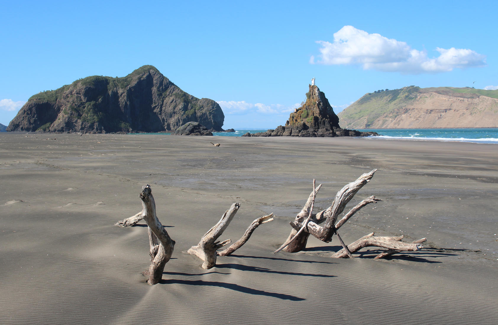
The desolate beauty of Whatipu
Our last adventure on this trip brought us to the spectacular and desolate wilderness of Whatipu, a black sand beach on Auckland’s rugged west coast. The drive out to the beach from central Auckland takes about an hour, with the final stretch from Little Huia on a particularly windy gravel road. It’s pretty remote so there was not much in the way of traffic, though it was something of a surprise to find temporary traffic lights (sensor operated) in the middle of nowhere after the road had been narrowed by some washouts.

Whatipu Beach and Paratütai Island
It is hard to imagine many people coming here at the best of times, but there are likely to be even less at the moment as many of the tracks in the area are closed due to the threat of Kauri die-back disease (entrances to the tracks are sealed off and signage blanked out). Thankfully, the beach and the track to the caves were still open (though not the camping ground near the caves). There were about five cars parked up when we arrived and that number stayed pretty constant throughout our 3 hour visit.
The reward for our slightly awkward drive was a wander through the scientific reserve with its beautiful combination of black sands, volcanic rock, wetland, dunes and wild sea almost undisturbed by other humans. It’s a popular spot for visitors of the flying kind too. As we explored we came across plenty of birds, including fantails, a spur-winged plover, black oystercatchers, paradise shelduck, pūkeko and some juvenile black-backed gulls.

Bluebottle at Whatipu
The black sands looked at their most desolate against driftwood that had been twisted into strange positions, including one that looked a bit like a crocodile waiting to pounce. There was a real threat here, albeit somewhat less deadly, in the form of stinging bluebottle jellyfish (otherwise known as the Portuguese man-of-war) that had been washed up onto the beach where they lay half buried in the sand ready for any unwary souls walking barefoot.
The waters here at Whatipu are pretty treacherous for all. The strong rips and currents mean that swimming is inadvisable and the threat to shipping from the constantly shifting sand is signalled by a lightbeacon (one of seventy five around New Zealand) situated atop nine pin rock. It is also worth being a little cautious around the land-locked cutter rock which half collapsed in 2007.
New Zealand’s worst maritime disaster occurred here with the sinking of the Royal Navy corvette HMS Orpheus on 7th February 1863. The corvette had ignored the signals issued by the Paratutai Signal Station and took an ill-fated course that saw her break up on the Manukau Bar with the loss of 189 souls. After further incidents the Royal Navy withdrew permission for their ships to enter the Manukau Harbour.

Driftwood at Whatipu
After exploring the beach we headed back inland and along the volcanic rock cliff face to the Whatipu caves. Hard as it is to believe, the largest of the caves (Te Ana Ru cave) once reverberated to the sound of music as revellers danced the night away on a kauri ballroom dance floor now buried underneath the sand.
There is more information about the history of Whatipu in the Whatipu Heritage Walk booklet provided by Auckland Council along with a map showing which tracks in the Waitākere Ranges Regional Park are still open.
Gallery


Takahē on Tiritiri
Our visit to Tiritiri Matangi island coincided with Takahē awareness month. The critically endangered takahē, are flightless birds with a large red beak and feathers in a beautiful combination of blue, green and turquoise. It is astonishing that they have survived given that how easy prey they are for predators, particularly stoats which began to decimate the bird population in New Zealand not long after their introduction in the 1880s.
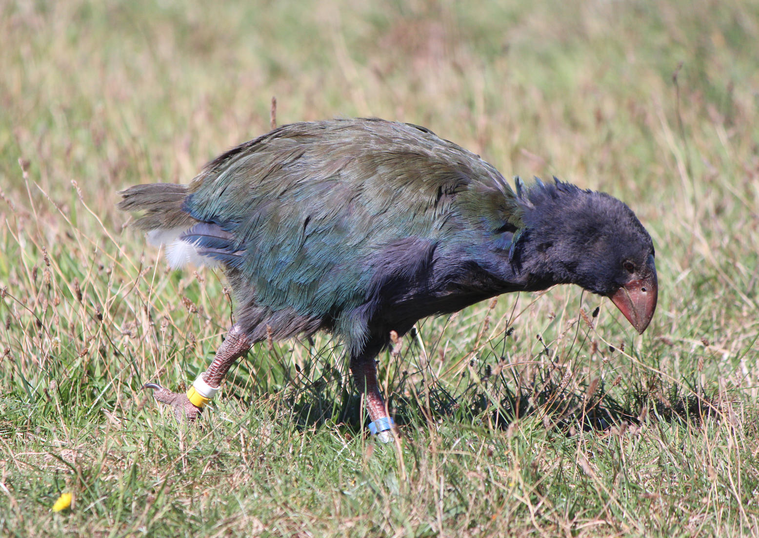
Takahē on Tiritiri
The Takahē were thought to be extinct until a small population of the birds was discovered clinging to life in the remote Murchison Mountains of Fiordland in 1948 by Dr Geoffrey Orbell. The difficulty of the terrain, not ideal for a bird that would be more at home in flat wetlands, played a key part in their survival. The predators which had wiped out most of the species had been deterred by the harsh mountains and unforgiving climate.
The Murchison Mountains were closed to the public in the wake of the discovery and a conservation programme initiated to help save the species. Predator free island nature reserves like Tiritiri Matangi play an important part in this process as safe places for breeding and also act as a safeguard for the species if something catastrophic should occur to the wild population in Fiordland.
The very real threat to the species was illustrated by a near catastrophic loss when stoats breached the natural and man-made barriers in the Murchison Mountains in 2007, resulting in a loss of nearly half of the Takahē population within a few months. The official takahē population count for 2017 recorded a total of 347 birds across the country, including 100 breeding pairs.
Tiritiri Matangi is currently home to eight takahē. On our visit to the island we were able to see the family that tends to stick around the Lighthouse compound, a place they associate with safety. It was an absolute privilege to see these beautiful creatures at such close proximity and appreciate just how lucky we are that they have survived.

The beautiful colours of the Takahē in the midday sun
Throughout April the Department of Conservation rangers are feeding the takahē at approximately 1:30pm each day, but they were easily seen long before this offering plenty of photographic opportunities (all taken at a respectful distance using a zoom lens). I took a fair few photographs and then put my camera down to watch these charming creatures, seemingly wandering with barely a care in the world. A joy to behold.
Gallery


Bird paradise at Tiritiri Matangi
The predator-free wildlife sanctuary of Tiritiri Matangi island in the Hauraki Gulf is one of the conservation success stories in New Zealand, as well as a really rewarding day trip from Auckland by ferry. The promise of some beautiful autumnal weather persuaded us that it was time to find out what the fuss was about.

Trinity Wharf on Tiritiri Matangi
Tiritiri Matangi was originally a forested island but a couple of centuries of farming resulted in the loss of 94% of the native bush and with it much of the original wildlife. In the late 1960s Tiritiri Matangi Island was designated as a reserve but it was the bold plan of a couple of young academics that really put this place on the map. Their plan, to recreate a forest, saw thousands of volunteers plant 280,000 trees over a ten year period from 1984.
The successful establishment of a replacement ecosystem has been followed by the re-introduction of some of New Zealand’s rarer native birds, such as the takahē. Today, the island is a much loved open wildlife sanctuary with a dedicated volunteer base.
On boarding the ferry it was pretty clear that we were in the company of some pretty dedicated bird spotters, whereas I would struggle to name more than a handful of bird species. I can tell the difference between a parrot and a pigeon, but don’t ask me to tell you what a swallow or a finch looks like. Luckily, you can book a guided tour with one of the volunteers when you buy your ferry ticket.
Once we arrived on the island it turned out that almost everyone was going on a guided walk. Two options were offered, one through the oldest bush on the Kawerau Track and the other through the re-planted and much younger bush of the Wattle Track. We were among a relatively small number choosing the latter, a shorter walk, which we thought would make a good introduction to the island.
In our small group of around eight, we set off at a deliberately slow pace. It was a delight to see birds flying all around us as soon as we left the main road, onto the Wattle Track. Frequent pauses on our walk allowed us to take in the sight of Tiritiri’s native birds, especially around the feeders. Our guide helped us to identify the birds that we could see and hear around us, while explaining the current state of growth of the bush and the stage ahead.

Tūī
It was all surprisingly addictive, as well as wonderfully calming. We had many moments on our own in the afternoon, standing still and absolutely silent on the Kawerau Track as the birds ignored us and flew around our heads. Over the course of the day we managed to see saddlebacks, bellbirds, stichbirds, takahē, pūkeko, whiteheads, north island robins, kererū, tūī and fantails. There was also a kōkako flapping its wings high in the canopy above us, though I didn’t manage to catch sight of the bird itself.
As if the birdlife wasn’t enough, Tiritiri Matangi is also home to New Zealand’s oldest operating lighthouse, first illuminated on 1st January 1865. The lighthouse was the first to be built by the New Zealand Government and only the third constructed in the entire country. The prefabricated cast iron tower was manufactured by Simpson & Co in England, whose name can still be seen on either side of the doorway, and hauled up to the construction site by twelve bullocks.

The lighthouse at Tiritiri Matangi
Although you can’t go inside the lighthouse you can wander around the outside. The lighthouse, neighbouring signal station and the surrounding homestead are very photogenic. Hopefully, plans to open a Lighthouse Museum in the old workshop will come to fruition. In the meantime, a wonderful booklet to celebrate the 150th anniversary shares a little of its history and the life of the lighthouse families.
Our visit came to an end all too soon, finishing with a lovely walk along the Hobbs Beach Track to Trinity Wharf in perfect time to make the only ferry back to Auckland. The ferry schedule gives you just over five hours on the island which seems like alot until you start wandering!
Gallery


The Karangahake Gorge and Waihi
On our leisurely return to Auckland we spent a couple of days around Waihi, a location which offers a splendid array of quite different sights – the natural beauty of the Karangahake Gorge and the Owharoa Falls; preserved industrial remains at the Victoria Battery; the gold mines of Waihi and the surf of Waihi Beach.

The concrete base that supported the cyanide tanks at Victoria Battery
The Karangahake Gorge is a popular spot for day hikes, rich in natural beauty, but turn the clock back a century and you would have found a rather different spectacle. The area would have been dominated by cyanide tanks and large stamper batteries constructed to process and extract gold from the ore being mined in the area. The foundations of many of these still remain and can be seen along the many walking circuits, but it’s hard to get a sense of the scale of industrial activity now that nature has reclaimed the land.
A little further down the road, at Victoria Battery, you get a little more of the picture. The Victoria Battery was constructed to process ore from the Martha Mine in Waihi. Today, the Victoria Battery is a peaceful site with industrial remains nestled in a green landscape, but in its heyday this would have been a hellish place to witness with 200 steel crushers hammering way constantly and kilns burning non-stop. The crushed ore was mixed with potassium cyanide and the sludge generated by the process discharged into the rivers.
The discovery of gold re-shaped the landscape in other ways, with the construction of a hydro-electric dam on the Waikato River and the construction of the Paeroa-Waihi railway line. The latter is no longer in everyday use but you can ride a part of it on the heritage Goldfields Railway and walk another stretch on the Karangahake Gorge: Rail Tunnel Loop short walk.
The gold industry is far from finished. The open cast Martha Mine still sits at the heart of Waihi and remains open to this day, albeit a little quiet right now while measures to address a major slip are put into place. Once this is in place modern processes can extract gold that would have been impossible a century ago. A minibus tour from the Gold Discovery Centre gave us an opportunity to get a closer look at the mine and the plant where the ore is crushed and processed.

Martha Mine
One of the landmarks on the perimeter of the mine and its rim walkway is the Cornish Pumphouse, a relic from the mine dating back to 1904, which was moved by 300 metres at a cost of 4 million NZ dollars in 2006 when monitoring revealed that the historic building was tilting and that the land underneath was continuing to move. It’s one of a number of community projects that are going on in the town to give something back.
Our time in the area was limited but we saw as much of this fascinating story as we could and still found time to sample a few of the pies and slices that are sadly absent from the other side of the world!
Gallery


Sunset over Whakatāne
After returning from White Island there was still plenty of daylight left, so we took a drive over to Ohope Beach, voted NZs most loved beach in a poll a few years back. It’s a gorgeous stretch of coast line and a popular holiday destination. On a quiet weekday it was more or less deserted. The beaches in New Zealand always seem to have a little surprise up their sleeves. In this case, the sea had perfected the most beautiful natural artworks on the beach.

Sunset over Whakatane
In the late afternoon I took another walk, along the waterfront, to the point where the Whakatāne river meets the sea and waited for the sunset. One of the landmarks at this point is the Wairaka statue, situated on a rock, which was given to the town on 27th November 1965 by Sir William Sullivan. It’s a landmark with a story.
Wairaka was the daughter of Toroa, Captain of the Mataatua waka (canoe). The men had gone ashore, leaving the women and children on the waka. While they were away the boat began to drift back out to sea. In Maori culture women were not allowed to touch the paddles, but knowing that they would be doomed if she did not act Wairaka picked them up and cried out “kia tū whakatāne au i ahau” to give her the authority to take the place of the men. Wairaka’s actions saved her people and gave the town it’s name.
The statue also turns out to be a popular pigeon perch as I discovered at sunset!
Gallery


Wanders around an active marine volcano
A spot of good fortune saw the best weather of our trip coincide with our long awaited trip to White Island, an active marine volcano in the Bay of Plenty that was given its name by Captain Cook on 1st November 1769. It is believed to be around 150,000 to 200,000 years old and is the northernmost volcano in the Taupo volcanic zone.

White Island (Whakaari)
The 49km journey out to the privately owned island (on the Peejay IV) took around one hour and twenty minutes on a wonderfully calm sea, albeit with choppier waters for the final 10 minutes of our approach towards the island. Once we were moored offshore groups of eight were transferred to the island in an inflatable wearing life jackets, hard hats and gas masks.
On reaching the island we had to step up from the inflatable onto metal ladders set into the landing stage and then make our way across the boulders to the beach. The tour party was split into two groups of around 25 to take a walk around the inner crater.
First up, the safety briefing. Our tour guides stressed the importance of sticking to the path they had taken and not wandering off. To illustrate this point, they highlighted a relatively benign looking mound with a grey crust. These innocent looking sights are best described as egg shells as there is no way of telling how thick these crusts are from looking at them. Their hollow interiors could easily hide a boiling pool of water, mud or something far nastier.

Exploring White Island
Volcanoes can be unpredictable beasts so we were also given a run through of the evacuation plan in the event of an eruption. If the volcano starting spewing out rocks, the advice was to shelter behind even bigger rocks! Thankfully, this was reckoned to be quite unlikely. Volcanic activity is measured on a scale of 1 to 5, with White Island currently on 1 for ‘minor volcanic unrest’. In the past it has spent 90 seconds at 5 for ‘major volcanic eruption’.
The first groups to return to the island three days after the eruption of 2000 had no idea of the conditions they would find. They discovered that the ladders were encrusted with volcanic material which had not entirely set, giving it the consistency of chewing gum. Apparently, one of the tour guides picked up a large rock to show his group but dropped it as it was still hot. On reaching the ground it broke in half, revealing a still molten core!
In 2003 monitoring equipment was put in place, including 24 hour cameras that allow remote observation of activity in the crater. These have helped pick up recent developments, including clear indications that the crater lake is starting to reform.

Steaming sulphur chimneys
Our walk took us around the sights in the inner crater, starting with the strikingly yellow sulphur chimneys which were belching out steam. The potency of the steam was soon demonstrated when the wind changed direction and blew the steam towards us. We had all been issued with gas masks that we could use whenever we felt the need and boiled sweets to help generate more saliva (this was very effective at counteracting the effects of the environment on my throat) but on this occasion it was just enough to turn our backs to the steam.
The next stop was the crater lake, getting near enough to get a good view but not close enough to test how crumbly the cliff edge might be! From here, we headed on to a couple of streams with water coming from different sources on the island and got to dip our fingers in for a taste. The first had a flavour a bit like blood, showing the presence of iron, while the second had a tangy lemon flavour.
Finally, we reached the remains of the last sulphur mining operation on the island which finished in the 1930s. It was a pretty inhospitable and dangerous place to work, evidenced by the loss of all 10 workers from the operation of 1913-14 after a collapse of the crater rim caused a landslide. The remains of the factory amply demonstrate the corrosive nature of the environment.

The remains of the sulphur factory
The only survivor of the 1914 disaster was one of the camp cats, nicknamed Peter the Great, who was discovered by a re-supply vessel three weeks later. Peter was later re-settled in Opotiki and his long and happy life led to a long line of cats. Peter was supposed to have sired over 500 kittens and it is said that most of the cats in the area can trace a connection back to him!
Once our exploration of the rusting factory was complete we returned to the wharf, ready to make our way back to our ship by inflatable. There was time enough for a packed lunch (provided by the tour company) and a circumnavigation of the island before we headed back to Whakatane, accompanied for part of the way by a school of dolphins who happily played alongside the ship.
As well as taking boat trips to White Island you can also fly in by helicopter and mid-way through our tour we saw a couple of Volcanic Air helicopters arrive, swooping around the curve of the crater impressively and then dropping down onto the wooden landing pads. The view of the island from the air must be impressive, but I think I prefer the more relaxed views of our boat trip.

Our transport to and from the island – the Peejay IV
I was incredibly impressed with the efficient operation of the trip by White Island Tours, the smooth boat transfers to the island and the knowledgeable explanations provided by our tour guides. It has undoubtedly been the highlight of my trip to New Zealand and I would thoroughly recommend the experience. After all, how often do you get the opportunity to set foot on an active volcano?
Postscript
The terrible disaster at White Island on 9 December 2019 has shocked and saddened the world. My thoughts go out to the tourists and tour guides, their friends and all the families affected by the terrible tragedy that has unfolded.
Setting foot on the island earlier this year, I thought I understood the risks. The safety briefings and ongoing safety explanations on the shore, on the boat and on the island were very thorough. I took reassurance from the routine checks with GeoNet, the monitoring systems in place on the island and the long history of tours without incident. It was shocking to see how little warning there could be of an eruption. Now, I can see that I didn’t have the faintest clue and put my loved ones at more risk than I should have.
Gallery


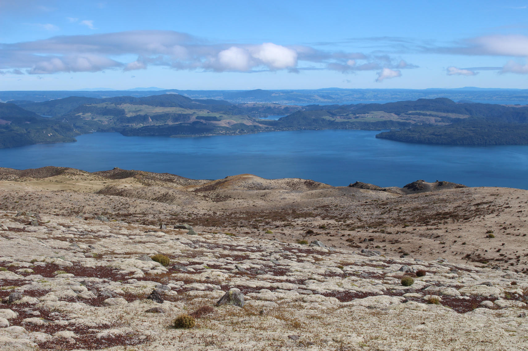
A hike around the Mt Tarawera crater rim
Twenty one years ago I came to Rotorua in the depths of winter and booked a four wheel drive trip to see the crater at Mount Tarawera, a dormant volcano. Unfortunately, the day served up thick fog and I could barely see a metre in front of me. The tour still ran, but it was pretty pointless as the closest I got to a view was looking at the scoria at my feet. I thought I would never get the chance to go back and see the view again, however fate has led me back here to rectify that.

The stunning colours and dramatic scenery at the crater rim
Things have changed a little since my first visit. Public access to Mount Tarawera was withdrawn in 2002 so the only way to go up to the summit is through a tour with the licenced operator, Kaitiaki Adventures. Also, one of the three domes of the dormant volcano (Wahanga) is completely closed as it is considered tapu (sacred) having been used as a burial site by the Maori tribe that owns the site, Ngāti Rangitihi.
Our trip with Kaitiaki Adventures took us by road for thirty minutes, then up an increasingly bumpy unsealed road and finally on foot to the top. Once we got up there we could stand by the crater edge and see the challenge that faced us on our crater rim walk. The steep scree slope we would need to descend to get to the crater floor looked particularly daunting from our starting point. However, under the guidance of our guides nothing was impossible.

Our slightly daunting path to the crater floor!
Our walk around the top was pretty straightforward, barring for a bit of wind and the angle of the scree slope, while still sleep, was somewhat less daunting once you got up close. The trick of making a descent was to dig your heels into the scoria and lean back a little, rather than letting your toes lead the way, pulling you forward into a probable tumble. It also needed a little pace – the slower you went the more difficult the descent would be. Everyone made it down safely and enjoyed a little breather before the climb back out on the other side.
The walk around the crater rim was exhilarating with incredible views in all directions, stretching from Taupo in the south to White Island in the north. Up at the top you got a really clear view of the 17km long rift that opened when Mount Tarawera erupted on 10th June 1886. It was striking to think that the landscape in front of us was created in just one night of deadly and destructive explosive force.

The view from the top of Mount Tarawera
Although the access restrictions are understandably not popular with everyone it has allowed the landscape to recover, particularly with the removal of invasive plant species, and it looks gorgeous in its raw natural state.
I was grateful for a bit of luck that was lacking twenty one years ago. Our walk was carried out in near perfect conditions, but the next scheduled walk was cancelled due to the bad weather that was expected to hit mid-way through the afternoon slot. Thanks to our excellent guide and driver, Ben and Steve, for a terrific morning.
Gallery


Waimangu Valley and Wai-o-Tapu
The geothermal delights of Rotorua have long been attracting visitors to the central plateau, but the sights on offer today are quite different to those experienced by the more determined tourists of the Victorian age. The reward for travelling to Lake Rotomahana by steamer, horse drawn coach, canoe and by foot would have been the extraordinary pink and white terraces.
The salmon pink siliceous sinter terraces at Lake Rotomahana were regarded as one of the natural wonders of the world. The spectacle had first attracted European visitors in the 1830s but the numbers really picked up by the 1870s after an increase in publicity ensured their existence reached a wider audience. All of that changed on 10 June 1886 when Mount Tarawera erupted.

Waimangu Volcanic Valley
The eruption created the Waimangu Volcanic Valley, the youngest geothermal valley in New Zealand, while destroying the pink and white terraces. It was assumed that no trace of the terraces remained, but a small piece was discovered at a depth of 60 metres in 2011. Today, visitors can take a walk through this young geothermal wonder and take a cruise on the lake. Sights include a steaming acidic crater lake, steaming cliffs, a multi-coloured terrace, geysers and an assortment of steam vents (fumaroles).
On our visit we had a couple of hours to wander along the set route through the valley, followed by a cruise around the lake and a bus ride back up to the entrance. In the afternoon we continued on to another geothermal wonder, Wai-o-Tapu, with some equally delightful spectacles, including extensive sinter terraces and a bright orange edged ‘champagne pool’ that was drawing gasps of wonderment from everyone as they got their first look.
The geothermal delights of Rotorua are astonishing to explore, but deserve a bit of time to see properly. I first visited both sites on a minibus tour in 1998 that only allotted a few hours to the two sites in total, whereas on this trip we were able to devote an entire day. It is perhaps no surprise that my main recollection of that trip were of running down the gravel tracks to try and see everything, rather than the spectacle I was supposed to be enjoying!

Champagne Pool at Wai-o-Tapu
I really appreciated the time on this trip to understand the events that led up to the creation of the natural wonders we can see today and the price paid by some of the unlucky tourists in the late 19th and early 20th century whose visits coincided with the most significant changes in geothermal activity. The most recent of these events took place in 1917 when the hydrothermal eruption of Echo Crater created Frying Pan Lake.
I think this is one of those places that you have to see for yourself, as no pictures can really do the place justice, but I’ve picked out a few shots to give a little flavour of the place.
Gallery


Geothermal delights at Orakei Korako
Our travels have brought us to Orakei Korako, a spectacular geothermal site between Taupo and Rotorua. The site is an interesting one, located across the waters of the Ohakuri Dam and only reachable by boat. It’s a little bit off the main tourist path so it doesn’t tend to get as busy as the geothermal sites in Rotorua but has been gaining more attention since Lonely Planet declared it as ‘arguably the best thermal area left in New Zealand’.

Across the water to Orakei Korako
The history of the site is a long one, beginning with the settlement of the area by the Maori tribe Ngati Tahu-Ngati Whaoa who used the natural geothermal resources in their daily lives. The spectacular formations have attracted visitors since the early twentieth century, though the waka that were initially used to ferry tourists across the water to the site have long since been replaced by more modern ships.
The colourful silica terrace that greets you when your ferry gets closer to the other side is simply spectacular and amply explains why tourists have made such an effort to come here over the past 100 years. At one time there were silica terraces of even greater repute at other nearby locations, though these have long gone. The Emerald Terrace is now the largest of its kind in New Zealand and what you see on the surface is only part of the story.
In 1961 the completion of the earthen Ohakuri Dam saw the water level rise 160 feet above the original water level of the river, submerging two thirds of the geothermal area. Today, the silica terraces continue for 35 metres under the lake hidden from human gaze. It is stunning now, so it is hard to comprehend how much more amazing it must have been in its original state.

The colourful sights of Orakei Korako
As we explored the site over the next hour or so we discovered more wonders, such as the ‘Golden Fleece’ terrace (a fault scarp formed in 131 AD); the Rainbow and Cascade Terrace; the ‘Kohua Poharu’ mud pools and the Soda Fountain.
The site also features one of only two known geothermally located caves in the world (the other is located in Sicily) possibly created by a massive geothermal eruption. Known as the sacred cave it holds a poignant plaque in memory of Atama (Adam) Mikaere who was killed in the Far Libyan desert, aged 22, in 1941. The inscription reads ‘His spirit hovers in this lovely cave where as a lad he guided and delighted visitors with his manly bearing’.

Who doesn’t like the sights and sounds of a bubbling mud pool?
Over the next couple of days we should get to see a few more geothermal sights and see the results of some of the volcanic eruptions of the past as we explore the area around Rotorua, but this was the perfect way to start.
Gallery


The Taranaki Falls and a little of Taupo
How do you follow an exhausting walk like the Tongariro crossing? According to the genius itinerary planning completed in the comfort of a desk in South London the answer seemed to be another hike! Hmmm…

The view at sunrise over Lake Taupo from our apartment at Oreti Village Resort
I had doubts about the plan as I headed to bed last night, but awoke feeling surprisingly fresh and ready to get walking again. A hike it was then. We drive south to the Tongariro National Park, parking up at Whakapapa Village near the incongruous hulk of Chateau Tongariro (a grand hotel built in 1929 to encourage tourists to visit the area).
The hike for today would be the two hour loop to the Taranaki Falls, choosing to start from the more exposed upper track as I think this is the easier way round and offers a succession of watery treats for the return leg.
After an hour of walking through alpine grasslands, red tussock, eroded volcanic soil and a forest of mountain toatoa we descended 100 steps to the satisfying sight of the falls. The weather was pretty grey, so I had plenty of time to muse upon my good fortune in doing the Tongariro Crossing in the considerably better conditions of yesterday.
My breath was taken away by the sight of the water tumbling 20 metres over lava flow which spewed from Ruapehu in an eruption 15,000 years ago. The way back offers further sight of the water flowing away from the falls, passing through a narrow gorge and over the Cascade Falls down to the Wairere Stream. There are a multitude of smaller delights, such as a small section of path completely covered in exposed tree roots. I have rarely seen a walk quite so varied. I was completely charmed by this.

The Huka Falls in Taupo
After a spot of lunch we drove around Lake Taupo to the Craters of the Moon, an hour long walk on a thermally warmed boardwalk around some smoking craters; the spectacular Huka Falls and a brief stop to admire the small wooden church at Mission Bay. A relatively relaxed afternoon which my tired feet certainly appreciated!
Gallery


Taking on the Tongariro Crossing
I have been wanting to tackle the Tongariro Alpine Crossing for 21 years so when the opportunity to add it to our itinerary for this trip came up I grabbed it. The 19.4km crossing takes you across the volcanic terrain between Mt Tongariro and Mt Ngauruhoe, climbing 800m in altitude from Mangatepopo car park to the summit of red crater (1886m) before descending 1000m to the finish point at Ketetahi car park.

The sunrise over the Tongariro Crossing
Our accommodation at Oreti Village on the shore of Lake Taupo was a fair drive from the national park, requiring a drive through the darkness to reach the start point as the sun rose. The outlook for the day was good and thankfully the thick fog we encountered on the drive was nowhere to be seen as I started my walk. The advice given by the Department of Conservation is to begin before 8am, allowing plenty of time to complete the walk in daylight with plentiful stops to take in the scenery.
Although I was hiking on my own, I was far from alone. When I first read about the hike in the 1990s the Tongariro Crossing received around 20,000 visitors in a year but by 2015 that had risen to 109,000. I didn’t get the sense that this was one of the busiest days on the crossing and everyone was fairly well strung out after not too long. A key indicator of this was that the toilets placed strategically across the route never had more than 1 or 2 people queuing at most. Perhaps this is no surprise, this is the shoulder season and I was taking to the crossing after a string of fine days (hikers often funnel into the first fine day after bad weather).
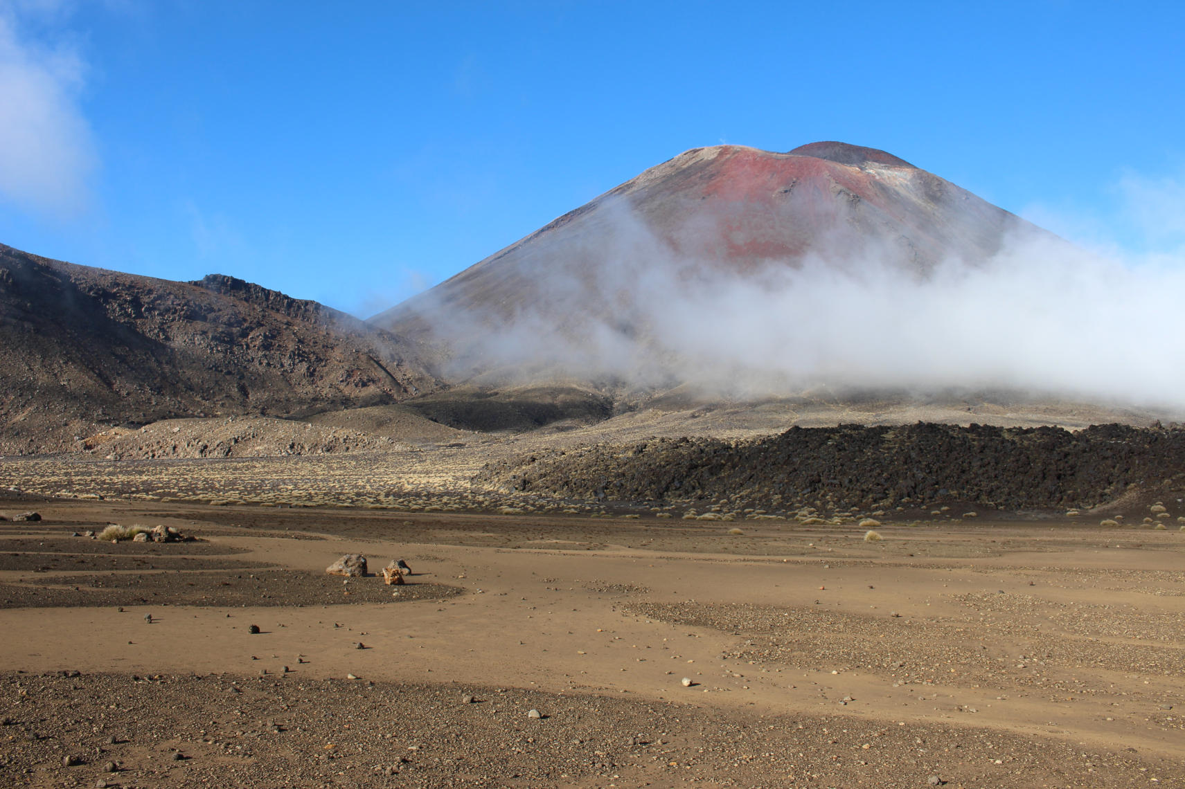
A view across the south crater to Mt Ngauruhoe
I was glad to have worn layers of clothing to cope with the cold at the top and the sun-warmed slopes of the latter stages, having seen plenty of folk ill-prepared for the conditions that awaited them on the walk. It was a problem recognised about ten years ago, when the word ‘alpine’ was added to the name of the hike to stress the strenuous nature of the route. The weather forecasts suggest that a few days after my attempt the crossing will see the first snow of the season and temperatures at the tope are predicted to drop to -6.
The Department of Conservation provides a handy checklist of essentials for the hike. I was carrying the recommended amount of fluid (1.5 litres), plenty of food and scroggin to give me an energy boost when I needed it. I probably could have done without the bulky photographic equipment, but ditching that was never an option! One thing I really valued was a pair of tough, fingerless gloves that I could use on some of the rockier sections.

Incredible views abound in every direction
Before I started my walk I wondered how I would cope with the devil’s staircase, where you ascend from 1400m to 1600m to reach the south crater. It was an exhausting effort for sure, but for me the trickiest part would be the steep descent from the red crater on the loose scree. I stayed upright through my descent but could understand entirely those who had chosen to slide down on their backsides.
The scenery throughout the walk is marvellous and surprisingly varied. The view from the south crater to Mt Ngauruhoe was the first treat, especially with the low cloud hanging below the peak. The black summit is a brooding presence in the dramatic landscape and you could see why this was picked as Mount Doom for the Lord of the Rings films. That’s not to discount Mt Tongariro itself, which was thankfully well behaved on my walk. It last erupted in 2012, sending hikers scurrying down as fast as they could manage (it’s well worth reading the sign along the way telling you what to do in the event of an eruption just in case!).

First view of the emerald lakes
The biggest smile that crept across my face during the walk was on the first glimpse of the emerald lakes glistening in the autumnal sun. It felt like a terrific reward for all that initial effort, though it was a little sobering to realise that this was just the half-way point. I took the chance to sit down and eat my lunch by one of the lakes, watching as some Danish lads demonstrated their impressive skill at stone skimming after carefully selecting the best stones on offer.
The last three kilometres seemed like some of the longest of my life, so I was glad to have some music to help me through the final stages (a little bit of Strangeland by Keane and the most recent album by White Lies). I was very glad to see some familiar faces at the exit from the crossing. A car park has never looked so beautiful or been anticipated quite so eagerly!

Nearing the end
I took 7.5 hours to complete the hike, but that did include a 45 minute wait at one spot for the crowds and clouds to clear to get the perfect shot. I’m glad I wasn’t attempting this in high season or that might have been a complete impossibility.
Overall, I thoroughly enjoyed the experience and would highly recommend it. It is, without doubt, the most amazing hike that I have ever completed in my life and absolutely worth waiting 21 years for.
Gallery


A three cave day
Our overnight stay in Waitomo allowed us to make an early start on three of the cave experiences available in the neighbourhood.
The caves have been receiving visitors since 1889, when the main glowworm cave was opened to tourists by local Maori Chief Tane Tinorau. The sight is now one of the most popular tourist attractions in New Zealand with coaches arriving through the day from Auckland and Rotorua. Most tourists only see the one cave on their tightly scheduled coach itineraries, which is a shame as the Ruakuri and Aranui caves are even more spectacular in my opinion.
First on our list was the Ruakuri cave, discovered some 400-500 years ago after a Maori hunter was attacked by two wild dogs (kuri) just outside the cave. The cave was discovered to be the den (rua) of the wild dogs. Once the wild dogs were dispatched the area around the caves became home to the local Maori population and the cave entrance was used as a burial ground.

Inside the Ruakuri cave system
The Ruakuri caves were opened to visitors by the Holden family in 1904. The NZ government claimed ownership and operated the caves until 1988 when the Holden family were able to re-claim ownership. However, with the dry access point through the burial ground out of bounds a new entrance had to be constructed. Many millions were spent digging a new and spectacular spiral entry point and the caves re-opened to the public in 2005.
The caves are now entered through a temperature controlled air-lock that makes it feel as though you are about to enter the lare of a Bond villain. Instead, what awaits is a wonderful walk through the caves on a series of walkways and bridges. The sights were a delight but as much as anything, it was the ability gto get up close to the glowworms that was realkly fascinating. We could see the glowworms moving about the rockface and all the threads they had dropped to catch insects.
Next up on our itinerary was the glowworm cave, which is the one most tourists see. It is a spectacular, if short, experience as you take a short boat trip in absolute silence looking up through the darkness to the thousand of glowworm tails that light up the ceiling. It was the most touristy of the three caves we entered but that doesn’t lessen the enjoyment.
I was particularly impressed to learn that since the cave was returned to the ownership of the descendants of Chief Tane in 1989 the majority of the staff working on the site are descendants of the chief and his wife Huti.

Inside the Aranui cave system
Finally, we visited the Aranui cave which was approached through a short walk through the forest accompanied by a couple of friendly fantails who hopped about and showed off us as we walked. Our wonderful tour guide Missy explained some of the useful plants we were passing and the Maori way of being guided by nature, eating the leaves that the insects have nibbled.
Once inside, we were once again treated to some incredible formations and a highly decorated ceiling, though I didn’t like the large wetas at the cave entrance or the information from our guide that they can leap a metre and cling on tightly! We all agreed that this was our favourite of the day. Across all the caves we were invited to spot the various shapes formed by the stalactites and stalagmites, which had included bungie jumping kiwis, a statue of the madonna and an elephant. The Aranui added an entrance guarding dragon to the list!
The three caves are very different and each has a special magic that makes it worth seeing. In short, it is well worth doing the triple cave combination.
The road to Marokopa
Our trip to the central plateau began with the relatively uninspiring drive south on the motorway, escaping the humidity of the Auckland basin. At first the sights were pleasant but unspectacular, though I had to admire the people of Huntly for creating a lookout with a view of a power station. As someone with a love of industrial scenery that is something that really speaks to me!

Industrial scenery in Huntly
It was fascinating to see the snapshots of NZ life along the way, as well as more unusual activities such as tree felling (all road traffic was stopped in both directions for five minutes while a couple of trees in the adjacent forest were brought down) and a field of crosses being prepared in Ngaruawahia for Anzac day. We got more of a taste for local life in café stops along the way, sampling the baked treats and pies on offer.
The most surprising sight would have to be Hamilton’s oldest surviving church, St Paul’s Methodist church (1906), sitting in a green field site at Te Kowhai. The church was moved in January 2019 by Uplifting Homes in a remarkable 10 hour effort from Hamilton to its new location 15km to the south, ready to begin a new life as a cafe.
In the early afternoon we reached our accommodation for the night, the Top 10 Holiday Park in Waitomo, where we have a lovely two bedroom cabin with a fully fitted kitchen and shower. Once our tightly packed car boot was emptied (a masterpiece of jigsaw like arrangement) we headed back on the road with a lighter load to see the sights on the road from Waitomo to Marokopa.
The main attraction in Waitomo are the glowworm caves but the road to Marokopa offers some other treats that get overlooked by the majority of visitors – the Marokopa Falls, the Mangapohue Natural Bridge and the black sands of the beach at Marokopa itself.
First on the road is the Mangapohue Natural Bridge. An easy twenty minute loop takes you on a boardwalk through a limestone gorge and underneath a 17 metre high natural arch which is all that is left of an ancient cave system.

Marokopa Falls with a rainbow
Next up were the 35 metre tall Marokopa Falls, looking especially spectacular after a full day of rain yesterday with a heavy torrent of water tumbling over the undercut greywacke basement rock to a pool below. It’s not hard to see why these are described as the most beautiful in the country and to top it off the conditions had generated a rainbow over the river this flows into. This was an easy sight to see too, with a 10 minute walk from the road down to the viewing platform.
Last, but not least were the near deserted black sands of Marokopa beach. Starting from the small car park by the albatross anchor (a relic from a ship that foundered here in 1916 and remained on the beach for many years) we headed on to the sands for a walk into the wind.

The black sands of Marokopa
The views of the west coast from Marokopa are simply stunning and we pretty much had this to ourselves, barring a couple wandering arm in arm. It was hard to know where to look as there were wonders in every direction – the views along the beach and out to sea were beautiful, but the closer you got to the sandstone cliffs you could see the remarkable geology of the area and the rich fossil legacy. So much to absorb. Personally, I loved the striking mix of colours – black sand, white driftwood and orange cliffs. It was the unexpected highlight of the day.
Our day ended back at Waitomo, where we settled in to the cabin for the evening for a tasty meal accompanied by the first of many bottles from a box of Gibbston Valley Wines that we had brought with us!
Gallery


Familiar sights
Our base for the next three weeks will be the family home in St Heliers, a seaside suburb of Auckland sitting at the eastern end of Tamaki Drive. It has been three years since my last visit but was pleased to see that I could find my way around from memory. A little wander down to the sea front provided plenty of re-assuring sights and the temptations of Village Co-op Ice Cream Shop, though I resisted the latter for now!

The canopy of the Moreton Bay figs covers Tamaki Drive
One thing I had somehow quite forgotten were the two massive Moreton Bay fig trees that sit on Vellenoweth Green. The two trees are not too far short of 100 years and in that time have grown to a considerable size, completely covering the road with their canopy. Their aggressive roots have ripped up the pavement and no doubt disrupted any pipes that lay under the surface. It is not hard to see why they are not thought to be a good idea for roadside planting.
Over the next few days we plan to catch up with family, recover from our jet lag and relax a little before re-packing our bags for a trip to the central plateau.

leave a comment