The Taranaki Falls and a little of Taupo
How do you follow an exhausting walk like the Tongariro crossing? According to the genius itinerary planning completed in the comfort of a desk in South London the answer seemed to be another hike! Hmmm…

The view at sunrise over Lake Taupo from our apartment at Oreti Village Resort
I had doubts about the plan as I headed to bed last night, but awoke feeling surprisingly fresh and ready to get walking again. A hike it was then. We drive south to the Tongariro National Park, parking up at Whakapapa Village near the incongruous hulk of Chateau Tongariro (a grand hotel built in 1929 to encourage tourists to visit the area).
The hike for today would be the two hour loop to the Taranaki Falls, choosing to start from the more exposed upper track as I think this is the easier way round and offers a succession of watery treats for the return leg.
After an hour of walking through alpine grasslands, red tussock, eroded volcanic soil and a forest of mountain toatoa we descended 100 steps to the satisfying sight of the falls. The weather was pretty grey, so I had plenty of time to muse upon my good fortune in doing the Tongariro Crossing in the considerably better conditions of yesterday.
My breath was taken away by the sight of the water tumbling 20 metres over lava flow which spewed from Ruapehu in an eruption 15,000 years ago. The way back offers further sight of the water flowing away from the falls, passing through a narrow gorge and over the Cascade Falls down to the Wairere Stream. There are a multitude of smaller delights, such as a small section of path completely covered in exposed tree roots. I have rarely seen a walk quite so varied. I was completely charmed by this.

The Huka Falls in Taupo
After a spot of lunch we drove around Lake Taupo to the Craters of the Moon, an hour long walk on a thermally warmed boardwalk around some smoking craters; the spectacular Huka Falls and a brief stop to admire the small wooden church at Mission Bay. A relatively relaxed afternoon which my tired feet certainly appreciated!
Gallery


Taking on the Tongariro Crossing
I have been wanting to tackle the Tongariro Alpine Crossing for 21 years so when the opportunity to add it to our itinerary for this trip came up I grabbed it. The 19.4km crossing takes you across the volcanic terrain between Mt Tongariro and Mt Ngauruhoe, climbing 800m in altitude from Mangatepopo car park to the summit of red crater (1886m) before descending 1000m to the finish point at Ketetahi car park.

The sunrise over the Tongariro Crossing
Our accommodation at Oreti Village on the shore of Lake Taupo was a fair drive from the national park, requiring a drive through the darkness to reach the start point as the sun rose. The outlook for the day was good and thankfully the thick fog we encountered on the drive was nowhere to be seen as I started my walk. The advice given by the Department of Conservation is to begin before 8am, allowing plenty of time to complete the walk in daylight with plentiful stops to take in the scenery.
Although I was hiking on my own, I was far from alone. When I first read about the hike in the 1990s the Tongariro Crossing received around 20,000 visitors in a year but by 2015 that had risen to 109,000. I didn’t get the sense that this was one of the busiest days on the crossing and everyone was fairly well strung out after not too long. A key indicator of this was that the toilets placed strategically across the route never had more than 1 or 2 people queuing at most. Perhaps this is no surprise, this is the shoulder season and I was taking to the crossing after a string of fine days (hikers often funnel into the first fine day after bad weather).
A view across the south crater to Mt Ngauruhoe
I was glad to have worn layers of clothing to cope with the cold at the top and the sun-warmed slopes of the latter stages, having seen plenty of folk ill-prepared for the conditions that awaited them on the walk. It was a problem recognised about ten years ago, when the word ‘alpine’ was added to the name of the hike to stress the strenuous nature of the route. The weather forecasts suggest that a few days after my attempt the crossing will see the first snow of the season and temperatures at the tope are predicted to drop to -6.
The Department of Conservation provides a handy checklist of essentials for the hike. I was carrying the recommended amount of fluid (1.5 litres), plenty of food and scroggin to give me an energy boost when I needed it. I probably could have done without the bulky photographic equipment, but ditching that was never an option! One thing I really valued was a pair of tough, fingerless gloves that I could use on some of the rockier sections.

Incredible views abound in every direction
Before I started my walk I wondered how I would cope with the devil’s staircase, where you ascend from 1400m to 1600m to reach the south crater. It was an exhausting effort for sure, but for me the trickiest part would be the steep descent from the red crater on the loose scree. I stayed upright through my descent but could understand entirely those who had chosen to slide down on their backsides.
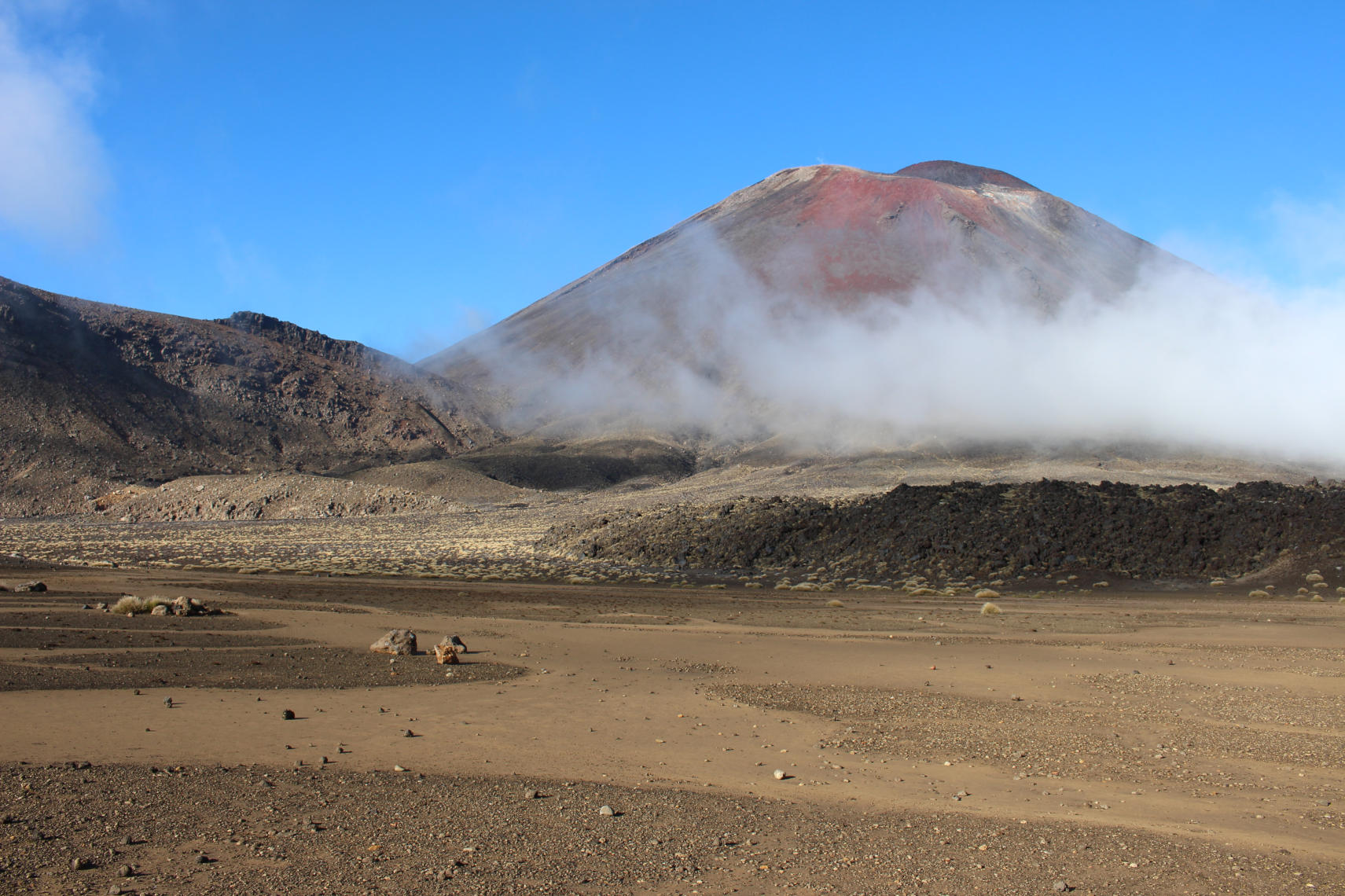
The scenery throughout the walk is marvellous and surprisingly varied. The view from the south crater to Mt Ngauruhoe was the first treat, especially with the low cloud hanging below the peak. The black summit is a brooding presence in the dramatic landscape and you could see why this was picked as Mount Doom for the Lord of the Rings films. That’s not to discount Mt Tongariro itself, which was thankfully well behaved on my walk. It last erupted in 2012, sending hikers scurrying down as fast as they could manage (it’s well worth reading the sign along the way telling you what to do in the event of an eruption just in case!).

First view of the emerald lakes
The biggest smile that crept across my face during the walk was on the first glimpse of the emerald lakes glistening in the autumnal sun. It felt like a terrific reward for all that initial effort, though it was a little sobering to realise that this was just the half-way point. I took the chance to sit down and eat my lunch by one of the lakes, watching as some Danish lads demonstrated their impressive skill at stone skimming after carefully selecting the best stones on offer.
The last three kilometres seemed like some of the longest of my life, so I was glad to have some music to help me through the final stages (a little bit of Strangeland by Keane and the most recent album by White Lies). I was very glad to see some familiar faces at the exit from the crossing. A car park has never looked so beautiful or been anticipated quite so eagerly!

Nearing the end
I took 7.5 hours to complete the hike, but that did include a 45 minute wait at one spot for the crowds and clouds to clear to get the perfect shot. I’m glad I wasn’t attempting this in high season or that might have been a complete impossibility.
Overall, I thoroughly enjoyed the experience and would highly recommend it. It is, without doubt, the most amazing hike that I have ever completed in my life and absolutely worth waiting 21 years for.
Gallery


leave a comment