Key Summit
The road north from Te Anau offers many wonderful sights that are easily slotted in to a trip to Milford Sound, but it is worth building in some additional time to take in the hike up to Key Summit, which New Zealand Tourism has described as the best Fiordland day walk. It was one of the first things on my list when we started making plans for a trip to the South Island and I certainly didn’t regret it!

The path to Key Summit
The walk takes you up a short section of the three-day long Routeburn Track (one of New Zealand’s nine Great Walks) which curves upwards at a steady angle, making it an easy-ish walk to tackle. On this stretch the track offers a beautifully shaded path, under the forest canopy, which features a delightful waterfall and just enough glimpses of the mountains to encourage you onward.
About an hour into the walk you hit a clearly marked signpost indicating the short uphill track up to Key Summit (taking you away from the Routeburn Track) and from here on in the views just get better and better. As you climb above the treeline it is impossible not to be stunned by the incredible beauty that surrounds you – it is fair to say that I’ve never taken a hike that delivered a punch quite like this.
I took the trek up at a speedier pace than I should have, for fear of the clouds closing back in but I really needn’t have worried. The skies had largely cleared by the time I had cleared the treeline, though the few that lingered between the forest floor and the mountain peaks presented a wonderful sight in their own right as they mingled with the tree tops.

The view towards Mt Crosscut/Paekaru
It is hard to imagine that the view from the top has many rivals – the 360 degree panoramic views over the Humboldt and Darran Mountains are simply breath-taking.
The summit also has the delights of an alpine nature walk leading up to a spectacular lookout with a view across to Lake Marian, a glacial tarn, with three peaks as a backdrop (Mt Christina/Te Taumata o Hinepipiwai, Mt Crosscut/Paekaru and Mt Lyttle/Puairuru). In absorbing this visual treat it’s easy to forget that all of this was carved by a glacier many thousands of years ago – what an achievement for a slow moving block of ice and rock!
At a reasonable pace the walk should take around three hours to the summit and back again, allowing plenty of time to soak up the view and take hundreds of photographs. I shaved a fair bit off that in my mad uphill dash, but I’m sure it is much more enjoyable if you don’t try repeating that!
Gallery


The road to Milford Sound
The 144 mile drive from Te Anau to Milford Sound presents one wonder after another, making it hard to resist stopping every time a sign highlights a new viewpoint, historic site or walk. However, it is quite impossible to do absolutely everything within a single day and still make it to Milford Sound in time for a trip on the water.

The Milford Highway
The skies were pretty grey when we made a start to our drive at 8.20am, choosing an early departure to give us a headstart on the coaches that come through here relentlessly later as morning progresses (the NZ Transport Authority advice states that most buses depart from Te Anau between 9am and 10am and advises independent travellers to hit the road before or after these times). The roads were fairly quiet, though we did have to weave our way through a flock of sheep along the way!
It is an astonishingly beautiful stretch of road to drive, even in the misty conditions that we faced this morning. At first you get delightful river scenes, fields full of pink and purple lupins and lakeside vistas but as you get closer to the Homer Tunnel the scenes become ever more mountainous and simply breathtaking with it. I anticipated this from everything that I read, but nothing quite prepares you for the scale of all this and the sense of wonderment you get from being surrounded on all sides by dramatic scenery.
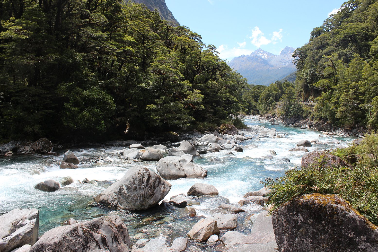
The Hollyford River
Although you are, in effect, driving to the middle of nowhere, you know that you are not alone in your endeavour (in 2015 Milford Development Authority reported that 530,000 visitors had made it to Milford Sound whereas the figure forecast for 2016 is 650,000). A significant part of Milford Sound’s appeal comes from its remoteness and this impression is re-inforced by the notices reminding you that beyond Te Anau there is no mobile phone coverage and that there are no petrol stations or places to buy food on the Milford Road until you reach Milford Sound.
Over the years there have been a number of proposals to shortcut the route for visitors arriving from Queenstown (a five hour drive) including a road tunnel, a monorail and now an electrified railway with car shuttles which would run from a spot just beyond Glenorchy to a terminus near the historic Gunn’s Camp. Maybe the practicalities of providing capacity for the ever increasing numbers travelling here will make such a scheme a necessity at some point. However, I can’t help but feel that this would take away part of the magic of Milford Sound.
After a couple of hours driving we reached The Divide, the starting point for the hike up to Key Summit, and it was at this point that the first gap in the clouds opened up. I made a dash for the summit, fearing that the clouds would close in before I could take advantage of the change in conditions, but my luck was in today. In the meantime, most of the coaches between Queenstown and Milford Sound passed through, leaving the roads much quieter for our onward journey.

The Homer Tunnel
In the afternoon we continued our drive at a leisurely pace, stopping off at a number of scenic viewpoints over the Hollyford River and Valley before the entrance to the Homer Tunnel loomed before us. The tunnel was opened in 1954, some sixty five years since the idea was first proposed by William Henry Homer, providing a route through the Darran Mountains down the Cleddau Valley to Milford Sound. Traffic lights regulate one-way traffic through the tunnel during the summer months with a countdown clock on display to get you ready for your turn.
Before taking our position in the queue we had a wander towards the rockface where an impressively hefty block of snow and ice remained, having somehow defied the summer heat of the previous week. Everyone and everything seemed so small against the astonishing height of the mountains. A more sobering reminder of the power of nature can be seen in the memorial plaques to the men killed in the avalanches of 1936 and 1937.

A block of snow at the Homer Tunnel portal dwarfs a couple of visitors
Once we were through the tunnel we stretched our legs at The Chasm and enjoyed the rather more human-scale delights of the waterfalls on the Cleddau River. Our journey concluded in mid-afternoon when we arrived at the Milford Sound Visitor Terminal, a good hour or so ahead of our boarding time for an overnight cruise on Milford Sound.
The Department of Conservation have put together a good map showing the various stopping points on the road between Te Anau and Milford Sound. Our chosen stops were:
1. Mackay Creek (51 km from Te Anau) for a good view of the wild lupins
2. Mirror lakes (56 km from Te Anau)
3. The Divide and Key Summit (83 km from Te Anau)
4. A couple of pull over spots where the Milford Sound Highway runs parallel to or crosses the Hollyford River
5. Homer Tunnel (99 km from Te Anau)
6. The Chasm (110 km from Te Anau)
It was hard to believe that so much natural beauty could have been packed into 144km of road before we had even boarded our boat to explore Milford Sound and we had only sampled a fraction of the views on offer. It made me appreciate once again that you need plenty of time to do this island any justice!
Gallery


Travelling south
I travelled south today, making my return to the South Island of New Zealand after a gap of nearly 18 years. On that occasion I didn’t travel any further south than the highway between Lake Pukaki and Lake Tekapo, whereas on this trip the same stretch of road will mark the northernmost boundary of our wanders.

On the approach to Mosgiel (with Kaikorai Lagoon and Green Island in the distance)
Our trip started with an early morning Air New Zealand flight into Dunedin (well, Mosgiel to be precise), followed by a drive on the state highway to Te Anau via Gore. The first section of the route through the southernmost parts of Otago reminded me how sparsely populated this part of the country is, though I couldn’t help but laugh at the grim humour of the sign outside one town that read ‘No doctor. No hospital. One cemetery.’
Along the way we took a small side-trip off the highway to visit the lighthouse at Nugget Point which has been in operation since 4th July 1870. The fog that had threatened to delay our landing at Dunedin had largely lifted but the landscape here was still partially shrouded in a light mist.

Nugget Point
The coastline on this stretch of the Catlins is pretty dramatic – the headland on which the lighthouse sits is surrounded by rocky islets (the Nuggets) which seemed to be a popular playground for seals. A little further back down the road is ‘Roaring Bay’ which is home to yellow-eyed penguins, though we were not surprised by their absence when we stopped by the hide here (they should have been out at sea catching squid for lunch).
After resuming our drive on State Highway 1 towards Gore we came to the relatively unremarkable town of Clinton, which gained a degree of fame in the 1990s after the election of President Clinton and Vice-President Gore. The stretch of road between the towns was re-labelled as The Presidential Highway and marked up with signposts and the Stars and Stripes.

Giant trout at Gore
A brief stop in Gore gave us a chance to admire a giant trout statue (along with a sign proclaiming Gore to be ‘World Capital of Brown Trout Fishing’) and grab a drink or two. Re-fueled and refreshed we continued our journey east, arriving in Te Anau at 4.15pm after a brief stop at the Wilderness Lookout (a viewpoint stands amidst an unusual piece of shrubland that gives a good impression of how the area might have looked eight to ten thousand years ago).
Te Anau is a curious but charming place, positioned perfectly as the last town on the road to Milford Sound and unsurprisingly dependent on the tourist trade (the number of beds in the town is almost twice the number of permanent inhabitants!). A one night stay was on the cards for us, before continuing our drive to Milford Sound in the morning. Time to grab some food and chill out!
Gallery


leave a comment